
The My Trail Company Down Light Hooded Jacket is a 800 fill power down jacket that’s well suited for hanging out in camp or as a way to augment a down quilt in an ultralight sleep system. Available with or without a hood, it has a 20d nylon exterior treated with DWR, elastic wrist cuffs to keep out drafts and a hood. Sizing is on the large side, so think about downsizing to the next smaller size. Priced at $119, the Down Light Hooded Jacket is an exceptional value at an unbeatable price…if it fits, but best used for three-season hiking and backpacking rather than winter use. Specs at a Glance
The MTC Down Light Hooded Jacket checks all the boxes for three-season use. With 110 grams (3.9 oz) of goose down, it’s the warmest down hooded jacket available at this price that I could find, by a long shot, with a comparable amount of 800 fill power down fill. 
That said, I’d encourage you to think about this jacket as a three-season coat, because the hood is non-adjustable. For example, you can’t shrink the volume of the hood if it’s too large; you can’t cinch the hood closed around your face with a drawstring to retain warmth; and there’s no internal collar at the neck to seal in your torso heat separate from the hood. Those are all features I look for on a hooded jacket or parka for winter hiking use in frigid temperatures, along with a few more ounces of goose down (For comparison, see my Montane Featherlight Jacket review.) (Note: Why are the My Trail Company prices so low? All of their products are “on sale”, all of the time. They achieve this by selling direct to consumers over the internet, rather than through retailers.) Given the sizing issues with the hood and it’s relative lack of functionality, I think you’d be better off buying the MTC Down Light Jacket without a hood for three season use, given it’s low price of $99, and simply augment it with a fleece cap in camp (which you probably already carry). With 100 grams of goose down, you’ll still get lots of warmth, and at $99, the price is also hard to beat. Do you really need a down jacket for three season hiking and backpacking? It really depends on where you hike and the climate. I always carry a down or synthetic insulated jacket, even on summer trips, because I hike in the mountains where temperatures are cooler and because my body chills rapidly as soon as I set up camp and stop hiking vigorously. Disclosure: My Trail Company provided the author with a jacket for this review.
from http://sectionhiker.com/my-trail-company-down-light-hooded-jacket-review/
0 Comments

The Chandler Brook Trail is a lovely but strenuous trail that runs from the Great Gulf up the side of Mt Washington past many lovely cascades, water shutes, and slides. You can make it into an interesting loop hike by descending by the Wamsutta Trail, which also has many unique views of the Northern Presidentials. I recently hiked this route after heavy rain, which was a bit sketchy because it’s so steep and slippery, but worth the extra effort for the views. The Chandler Brook Trail climbs 1300′ in 0.9 miles, so it’s not for the faint hearted. The bottom of the trail where it intersects the Great Gulf Trail can be difficult to find because of blow downs but once you get on it, it’s relatively easy to follow. Just head uphill. The thing that makes the Chandler Brook Trail so beautiful is rain, but that’s what makes it difficult too. There are four stream crossings, which can be slippery and hazardous when rain floods the stream. Of the four crossings, the lowest is the most challenging and I found myself bushwhacking about 50 yards uphill to a better, less exposed crossing, where the chance of falling down a waterfall was less great. The top of the trail runs through a small boulder field which is also exposed to the Mt Washington’s winds, before ending at 4125′ along the Mt Washington Auto Rd. From there, you can link up with the Nelson Crag Trail which is about 0.5 miles up the road or hike 1.2 miles to 5300′ where you can get on the Alpine Garden or Wamsutta Trails. All three of these trails are above treeline and fully exposed, so you want to make sure to have good visibility, low wind, and to avoid thunderstorm weather when hiking them. 
The Wamsutta Trail is 1.7 miles in length and good if you want to make a loop. It drops steeply back down into the Great Gulf, ending only about 0.6 miles from where the Chandler Brook Trail begins. The top of Wamsutta quickly drops into krumholz offering some protection from the My Washington’s winds. It then drops steeply through a maze of boulders, requiring good scrambling ability to get through in one piece. However, the effort is well worth the risk (yes risk, because this is not an easy trail), with unparalleled views of the side ravines on the other side the Great Gulf. This includes Jeffersons Knees, two precipitously steep subsidiary ridges belonging the Mt Jefferson, the third highest peak in the White Mountains. 
The bottom of the Chandler Brook Trail begins approximately 4 miles from the Great Gulf Trail parking area across from Camp Dodge on Rt 16. The full itinerary is as follows:
Total Distance: 12.2 miles with approximately 4,000 feet of elevation gain. from http://sectionhiker.com/hiking-mt-washington-a-chandler-brook-wamsutta-trail-loop/ 
A magnetic compass is designed to show you which way is north. Knowing that, you can figure out the other cardinal directions: east, west, and south. If you always know where north is, you can also walk in one direction and backtrack later to the point where you started. Why is that useful? Let’s say you step off a well-marked trail and walk into the forest to pee. Afterwards, you can use a compass to backtrack to the trail if you’ve forgotten which direction it is. This is easy if you know how to find north. While this may sound like a trivial example, hikers have died because they couldn’t find their way back to the trail after stepping off it to pee. I know of one hiker who died this way. It’s especially tragic because they were carrying a compass but didn’t know how to use it. I’d encourage you to take the next 5 minutes to learn this skill if you don’t already know how to do it. This example doesn’t require a map, topographic map reading skills, or understanding declination. It just explains how to use a compass:
These are the basic building blocks of using a compass. They’re easy to learn and the foundation of all land navigation. The Magnetic NeedleA hiking compass, like the one below, has a magnetic needle which spins around inside a dial. Most of the time, the north end of the needle is colored red or sometimes yellow. 
To Find NorthTo find north, pick up the compass and hold it level with the dial is on top. The red end of the magnetic needle will point north. Ignore all the other markings on the compass except the direction that the red half of the needle points to. Now: turn around slowly and continue to hold the compass level. As you turn around, the needle will spin inside the dial. But the red end will always point in the same direction, north, no matter which way you are facing. 
Put Red in the ShedThere’s an outline of an arrow inside the dial, called “the shed”. Turn the dial with the numbers on the outside , so that the red end of the magnetic needle fits inside the outline. This is called putting “red in the shed.” 
This doesn’t change the direction that the red end of the magnetic needle points to when you hold the compass level, it just makes it easier to locate North, South, East, and West on the dial, and the numbers, which are degrees that correspond with them. For example,
The hash marks in between the cardinal directions are also measured in degrees. 
Direction of Travel ArrowLet says you’ve been hiking along a trail and you need to pee. Turn the compass perpendicular to the trail in the direction you want to walk to take a pee. Holding the compass level in your hand with the dial on top, sight down the direction of travel arrow along the direction you plan to go. Twist the dial of the compass, so red is in the shed, while keeping the direction of travel arrow pointed toward you plan to walk. Read off the number at the bottom of the direction of travel arrow, which is 282 degrees the example above. Start to walk in the direction of the direction of travel arrow, holdings your compass level and in front of you, keeping red in the shed as you walk. This is called following a bearing. Walk out a ways and do your business. 
To BacktrackSubtract 180 degrees from the bearing you followed previously. Turn the dial, so that the number 102 (282-180) is at the base of the direction of travel arrow. Holding your compass level in front of you, turn so red is in the shed, and start walking in the direction that the travel arrow is pointing. This will return you to the point where you left the trail (or very close: people drift left or right 3 degrees when they follow a compass bearing, although this rarely matters over short distances.) If the first bearing was less than 180 degrees, you’d subtract 180 from it, and add the resulting negative number to 360 to get the back bearing. For example, if your first bearing was 60 degrees, you’d subtract 180 from it, and then add 360, which would give you your back bearing to the trail. (60-180)+360=240. Hint: if you don’t like math, trace your finger down to the base of the direction of travel arrow to the other side of the dial – see Figure 4. If the bearing to your pee point is 282, the back bearing back to the trail is 102. Basic Compass UseThese techniques are the basic building blocks for compass use. They’re so basic, you don’t have to have a map, know the difference between magnetic north or true north, or about magnetic declination to use them. All that comes later and builds on the techniques described here. Being able to find a fixed point of reference, in this case magnetic north, and to follow bearings relative to it is an incredibly powerful tool for hikers: a skill that is easy to learn and can save your skin. from http://sectionhiker.com/how-to-find-north-with-a-compass-and-backtrack/ 
I never expected to revisit Speck Pond after hiking the section of the Appalachian Trail from Grafton Notch down to Gentian Pond in 2009. Speck Pond is on the south side of Old Speck Mountain, a huge 4000 footer with a fire tower at the top. There’s a lean-to shelter and tent platforms there, and I remember camping under a tarp during a violent thunderstorm, helplessly watching the water pool on the tent platform boards and head in the direction of my sleep insulation. The next morning, I’d hiked through famous Mahoosuc Notch headed southbound on the AT. That was 8 years ago. Only this time I hiked in on a blue blazed trail called the Old Speck Pond Trail, one of several that connect the AT to Success Pond Rd, a gravel topped logging road which is one of the main backcountry thoroughfares in this part of the north country. My destination was a peak called Mahoosuc Arm Mountain, which overlooks Speck Pond and Mahoosuc Notch, followed by the pond below it. Success Pond Rd is a hoot, but not if you have a low clearance car like my Mazda 3, since there are places where its severely eroded. It’s a privately owned logging road where logging trucks have right of way and is an important short-cut between Berlin, NH and Grafton Notch, ME, cutting off an hour of highway driving time. Cell phone access is non-existent, so you have to have a vehicle you can trust when driving it, since sections of it are quite isolated. Most of the summer traffic on Success Pond Road is locals in 4×4’s, ATV’s, and some AT shuttle drivers ferrying thru-hikers and section-hikers to and from the Mahoosuc Trail segment of the AT. The road is closed in winter, although parts of it are used as a snowmobile trail. I only started using it myself a few years ago to get to remote trails and bushwhacks in the Mahoosuc Range, but like I said, it’s best travelled with a high clearance vehicle you can rely on. 
The Old Speck Pond Trail, like all of the hiking trails in the Mahoosuc Range, is rough and steep, wet, and full of rocks. They’re even tougher than the trails in the White Mountain National Forest, down south. This one looked fairly well maintained however, probably because the shelter at the pond is being replaced this spring and the work crews hike up to the pond and back from the road, about 3.5 miles one way. This being spring, the leaves hadn’t come out yet and didn’t block the view from the trail, so I could see much of the north country spread out before me including the Percy Peaks and the Devil’s Slide near Stark, New Hampshire. Higher up on Mahoosuc Arm, I could see Goose Eye Mountain and the Wright Trail Cliffs, two other peaks I climbed last summer about 10 miles south on the Mahoosuc Trail (AT). That Goose Eye Trip was a doozy. I’m always kind of awed when I see big mountains that I’ve climbed, just knowing that I managed to hike up them on my own. There’s a certain satisfaction, even an affirmation that “I exist”, that comes from knowing I stood on top of those peaks. The Old Speck Trail doesn’t come out at the pond, but high up on Mahoosuc Arm Mountain, and I had to give up a lot of elevation to get down to the water and the AT campsite there. It’s a really steep and wet trail, and this one still had snow in it, it being early June. Nothing like spring in New England! 
I toured the new shelter area – the old one was a dump when I’d visited the last time – and then headed to the pond for a snack. There I met a fisherman, actually a hiker with a fishing rod, who was rigging up a spinning rig to fish. He lives in Bethel, Maine and we talked about hiking and fishing in the area. Just a nice low key chat. Then I took my leave and hiked back up the trail and back down to my car below. It was eery lonely hiking back down through the hobble bush, so I sang a few songs to scare away any bears and moose in the area. 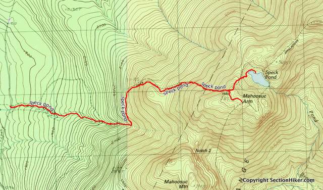
Speck Pond does look like it has a nice fish population and I bet you could have some fun paddling around in it in a packraft. But I don’t know when I’ll be back there again. Total Distance: 7.8 miles, 2500 feet of elevation gain. from http://sectionhiker.com/climbing-to-mahoosuc-arm-and-old-speck-pond/ 
The Thermarest Slacker Hammock Sleeping pad is a 26 ounce self-inflating pad with an R-value of 2.1. Given its weight and size when rolled up, it’s best used for hammock car camping rather than backpacking. While not as sexy as a underquilt, it’s far less expensive, easy to deploy, and perfectly sufficient for warm weather hammock camping. The Slacker Hammock Pad can also be used as a comfortable sleeping pad when you want to go-to-ground and sleep in a tent, extending its utility. Why do you need a sleeping pad or insulation underneath you in a hammock? The nighttime air is usually cooler than your body temperature. If you lie in a hammock without some sort of back insulation you’re likely to get cold at night, much like you would if you slept on bare ground without a sleeping pad. There are several types of hammock insulation solutions available to address this problem.

The Slacker Hammock Pad is fully symmetric and works well with simple camping hammocks or mosquito hammocks with integrated bug nets. It also works well if you can lie diagonally in your hammock, to get a flatter “lay,” instead of sleeping like a banana. The pad is made of urethane foam with a durable 75 d polyester cover. Perforated channels in the foam prevent the pad from buckling when you lie on it in the confined space of a hammock. Thermarest obviously took a page out the Klymit design playbook here, leaving gaps in the foam to reduce the weight of the pad and let it mold around your body in what they call an AirFrame design. The Slacker Hammock Pad is 75 inches in length and 26 inches at its widest. The middle section of the pad is wide enough to insulate your butt and torso, while the tapered foot and head ends of the pad fits into the narrower ends of a gathered-end hammock.The ends taper to 16″ but have a width of 20″ where your shoulders would be positioned, providing insulation for your upper body and arms unless you have a very wide torso. Technically self-inflating, the Slacker Hammock Pad does require a dozen breaths to fully inflate and has a standard Thermarest stick valve for this purpose. Deflation is a bit more challenging. Rolling up the pad, folding it in two, and sitting on it is the best way to compress it before stuffing it into its stuff sack. The included stuff sack can also serve double duty be used as a pillow or as a bolster under your knees to help prevent painful knee hyperextension, a common problem in shorter length, gathered-end hammocks. 
The Slacker Hammock Pad provides good stability when you lie on it although it won’t flatten the curved shape of a camping hammock if you lie on it along the centerline. It does work well on diagonal lay hammocks though, especially ones that are fairly wide. It’s also exceptionally easy to use, unlike most cottage hammock underquilts which require configuring a complicated suspension system every time you use them. While the Slacker Pad provides good three-season insulation for back sleepers and side sleepers, I wouldn’t recommend using it below 55-60 degrees at night given my experience using it and it’s relatively low R-value of 2.1 (which is the same as a Thermarest Zlite foam pad). Unfortunately, rating the temperature of under-insulation in hammocks is very subjective and there are enough individual differences between people that the only way to tell if a solution works for you is to test it out (and bring extra foam insulation along in case you get cold.) What’s the value of the Thermarest Slacker Hammock Pad over a simple foam pad? Well it’s a heck of a lot more comfortable than a foam pad, it’s pre-shaped to fit in a gathered end hammock, wide enough to insulate your shoulders and arms, and it can serve dual use as a comfortable ground pad when you sleep in a tent. Given its size and weight at 26 oz, it is best used for camping and not backpacking, where a more compact, lighter weight insulation option is preferable. Disclosure: Thermarest provided the author with a sample product to review.
from http://sectionhiker.com/thermarest-slacker-hammock-sleeping-pad-review/ 
The ENO SubLink Hammock Shelter System contains all of the components necessary for backpacking with a hammock, except foam padding or some other insulation to keep your back warm at night. If you’ve never hammocked or want to get into backpacking with a hammock, buying an integrated system like this is a good way to get started without having to become an expert right away. I bought my first backpacking hammock system this way used it on many trips before I started replacing components with gear from different vendors. This ENO hammock shelter system has it pluses and minuses, but it’s an above-average collection of components that will get you out the door without a huge learning curve and a lot of fuss. It terms of quality and completeness, it’s in the same general ball park as a Hennessy Hammock System or a Blackbird mosquito hammock/tarp combo from Warbonnet, but best used by people of smaller stature. Lightweight ComponentsThe emphasis of the SubLink Hammock Shelter System is light weight, and weighing in at 2 lbs 8.3 oz (on the sectionhiker scale), it includes the lightest backpacking products in the ENO product line.
While you could purchase each of these components separately for $269.80, you also get a price break when you buy them for $249.95 as a set. Let’s take a closer look at each of the components included: Sub7 HammockThe ENO Sub7 Hammock is basic nylon gathered-end hammock (includes wiregate carabiners), but it is quite short and narrow at only 105″ x 47″. When sizing hammocks, in order to lie flat, a good rule of thumb is to get a hammock that’s 4 feet longer than your height. 
At 8’9″, the Sub7 is still reasonably comfortable for me although I’m 5′ 10″. If you’re taller than that, this would be a good component to replace with something like a Hummingbird Hammock Single+ (9’8″/7.6 oz) or a Sea-to-Summit Single Pro (10’/12.7 oz). Longer is heavier, but that’s the way it is. (see: Hammock Length and Comfort Guide.) ENO Helios Hammock Suspension SystemThe ENO Helios Hammock Suspension System is really quite a nice Dyneema whoopie style setup w/ polyester tree straps. 8′ long (per side), it can be used on large trees or between wide gaps between trees that are longer than most camping hammock setups. Weighing just 4.1 oz, it’s also super light, and I’ve already started using it with all of the other non-mosquito camping hammocks I own. 
Whoopie suspension systems uses a bury-splice tension system mechanism (think Chinese finger trap) to maintain their length, eliminating the need for metal buckles. They’re very fast to adjust and give you the ability to fine tune your pitch, unlike a strap system that has predefined loops. ENO Guardian SL Bug NetThe ENO Guardian SL Bug Net (12.7 oz) slides over the Sub7 Hammock to prevent bugs from munching on you at night. The pull-on character of the bug net can be a little awkward if you have to get up during the night to pee, but it gives you the option to use the Sub7 without any netting when bug season is over or if you want to use it for traveling, say at a hostel or indoors. The alternative is to buy a mosquito hammock like the Warbonnet Blackbird which has a built-in bug net and side zippers, but then you’re always carrying that extra weight even if you don’t need insect protection. It really depends on what your priorities are: light weight or convenience. Some cottage makers, like Dream Hammock, make highly modular hammocks with components you can add or remove for every trip, but it helps to know exactly what you want beforehand because there’s no return policy for most custom gear 
The Guardian includes a ridgeline to keep the netting above you and off your face in the hammock, since the Sub7 doesn’t have one. When you get into your hammock, you pull the bug net up like a pair of pants and secure it around the hammock suspension with a toggle. It’s kind of a reach. Reverse the process, when you need to get up at night. ENO ProFly Sil Rain TarpThe ENO ProFly Sil Tarp is a 15d seam-sealed silnylon catenary cut tarp with 2 ridgeline and 4 corner guylines (126″ x 80″). All the guylines are reflective, so you can find your shelter at night with a headlamp, and have linelocs at the tarp end so you can adjust their length easily. The curved edges (catenary cut) of the fly help reduce weight and improve the tarps aerodynamics in wind. ENO also sells a ProFly Sil XL tarp which is two feet longer: this would be my preference to help prevent blowing rain from hitting the tarp at the ends. 
Coverage of your hammock is good but there are only a few inches on each side, so you’ll need to fiddle with the tarp to get your hammock centered under it. While there are linelocks on the tarp end of the ridgeline, you’ll need to tie a knot around a tree to secure the other end. For convenience you might consider adding a Figure 9 or Dutchware Wasp at the guyline ends of the ridgeline instead, so you can avoid a knot. 
The Bottom LineThe ENO SubLink Hammock Shelter System is built around a netless hammock, unlike many of the other backpacking-specific hammock shelter systems available today, like those from Hennessy or Warbonnet. While this provides better modularity and lower weight, it’s the linchpin that determines whether you build a backpacking hammock system around mosquito hammock (with permanent bug netting) or one where the netting in a separate component like the Gaurdian SL bug net. If gear weight is of **supreme** importance to you, a netless hammock like the Sub7 is the way to go. I never use my hammock when bugs are not present, so I’m perfectly happy to have one with built-in mosquito netting. The nice thing about the SubLink is that you can buy it and start backpacking with it immediately. The components work well together and you don’t have to spend 6 months becoming a hammock expert to start doing trips. There’s a lot to be said for that. Over time, you might want to replace some of the SubLink’s components once you really understand what’s needed where you backpack, and that’s to be expected. However, if you are 6′ or taller, I would recommend substituting a longer hammock than the Sub7 included in the SubLink system, since it’s on the short side. But if you’re smaller in stature, the ENO SubLink is a very lightweight, entry-level hammock system that should work well for you. Disclosure: ENO provided the author with a sample product for this review.
from http://sectionhiker.com/eno-sublink-hammock-shelter-system-review/ 
If you’re thinking about buying a camping hammock or looking to upgrade, the length of a gathered-end hammock can make a big difference in your comfort. The 4 foot ruleMost hammock experts recommend getting a hammock that is 4 feet longer than your height so you can lie nearly flat in it for sleeping. So if you’re 5′ 10″ tall, you’d want a hammock that’s 9′ 10″ long. Why the extra length? The ends of a hammock hang at an angle so you can’t use the full length of fabric. So, the extra 4 feet of fabric gives you enough length to get a fairly flat “lay” for sleeping when you’re stretched out at night. Longer hammocks also make it possible to stretch out diagonally in a hammock, which is good for side sleepers who want a flat surface. If your hammock is not long enough, you’ll sleep in a banana shape, which can lead to hyper-extended knees and knee pain. That’s why shorter length hammocks are best used for seats or lounging, rather than camping, at least for taller people. Yes. Longer hammocks are usually heavier than shorter ones. But the motivation for using a camping hammock is usually comfort and convenience not gear weight. When you add in all the other pieces of gear needed for hammock camping such as tarp, bug netting, back insulation, and a quilt or sleeping bag, hammocks are not that much lighter weight than a ground-based ultralight shelter and sleep system. Don’t be fooled into thinking that the lightest weight hammock will be the best one for sleeping, just because it’s lighter weight than others. This table lists the most popular camping and backpacking hammocks that people can buy off the shelf without buying a custom made hammock from a cottage manufacturer. While you can order a custom hammock from a cottage gear manufacturer, just understand that they have pretty long backorder delays and it’s not strictly necessary, unless you want a special color, fabric, or design. I have several of the gathered hammocks listed: the 10′ Warbonnet Blackbird, a Thermarest Slacker Single, ENO Sub 7, and Hummingbird Hammock Single, and sleep best in the Warbonnet because the extra length lets me lie flat. I’m 5′ 11″ and it’s the perfect size for me. The best hammock length for you will be one that you enjoy using. The four foot rule is just a guideline, but I’ve found it very helpful when buying hammocks for backpacking and wanted to pass it along.
from http://sectionhiker.com/camping-hammock-length-and-comfort-how-to-choose/ 
The REI Dash 2 Ultralight Tent isn’t made anymore, but it was the lightest weight tent that REI ever manufactured, weighing just 2 pounds and 7 ounces. I have a near mint one in my gear review closet I’d like to give away to a good home. The Dash 2 is a hybrid single walled/double walled tent with a hubbed poleset, two doors, and two vestibules to make it easy to set up. Many of the innovations and fabrics it uses have been incorporated into the latest generation of REI’s lightweight tents. You can read about the Dash 2 along with customer reviews at REI.com or my complete Dash 2 product review for more information Deadline to EnterThe deadline to enter this raffle is Monday, June 26, 2017, at midnight PST.
To EnterTo enter this random raffle for a chance to win a free REI Dash 2 UL Tent, answer the following three questions in a comment below:
Incomplete or unintelligible answers will be disqualified. Brevity is appreciated. Example ResponsesExample 1:
Example 2:
Example 3:
Please answer the three questions in a comment below to enter
Incomplete or unintelligible answers will be disqualified. Brevity is appreciated.
from http://sectionhiker.com/enter-for-a-chance-to-win-a-rei-dash-2-ul-tent/
It’s important to bring water with you when you go day hiking to replace the fluid you lose to perspiration, help keep you more alert and flush waste products out of your body. Not bringing enough water can lead to discomfort, while bringing too much can slow you down. How much water do you need and what’s the best way to carry it? 1 Liter every two hoursIf you’re actively hiking, it’s good to drink about 1 liter (32 ounces) of water every two hours. That’s a good rule of thumb based on my experience hiking year-round and in a wide range of climates. You might need more or less depending on the temperature, humidity and body weight, but that’s a good estimate of what you’ll need to carry if you can’t refill on your route. Water bottles are best carried where they are easily accessible on the outside of a backpack rather than being buried inside it. Backpacks with stretch side pockets are convenient, so you can reach back and grab a bottle to sip from while walking. Can’t drink and walk at the same time? Stop for a few minutes every hour and sip from a water bottle while you take a five minute break. How do you know how much water to bring?If you have a guidebook, it should give you a time estimate for your hiking route. If you just have a map, calculate the total distance of your hike. Divide that number by your pace in miles per hour. This will usually be somewhere between 2 or 3 mph. For example, I can hike 3 miles per hour on a flat trail. If the distance of my route was 9 miles, I’d want to bring 3 liters. It’s just an estimate of what I need, but fairly accurate. Does it have to be water?No. You can drink any non-alcoholic fluid. Water is usually cheap and easily available, but you can also drink tea or juice if you prefer, or add an electrolyte mix to your water to make it taste better.   
What about hydration packs?If you have a hydration pack or a backpack with a hydration reservoir pocket, being able to sip on a hose while you walk is very convenient for day hiking. It’s great because there’s such a low barrier to drinking and having a hose connected to your shoulder strap is constant reminder to take a sip. Buying a 3 liter hydration pack, like the ones shown above, is a good size for a long day hike. If you don’t need all 3 liters, don’t fill it up fully. How do you know how much water is left in your hydration pack?That’s one of the problems with hydration packs. You don’t know how much water is left in the hydration bladder when it’s hidden inside your backpack. That’s why some people prefer drinking out of transparent bottles. Hydration packs are super convenient though and you can just open your pack and check to see how much water you have left if you want to know. Can you drink too much?It’s unlikely. Your body is pretty good at flushing extra fluids out by making you pee. Peeing on a hike is normal and you shouldn’t be ashamed to ask your friends to let you take a bio break on a hike. The color of your pee is also a good indicator of your hydration level. If your pee is clear and copious, then you’re drinking enough. If it’s bright yellow or even brownish, you need to drink more water. Can you refill water bottles or a hydration pack on a hike?Absolutely. If you want to refill using a natural water source like a stream or lake, it’s best to filter or purify your water using a simple product like the Katadyn BeFree or Sawyer Squeeze that let’s you pour your filtered water int your bottles or hydration bladder. A Steripen is also an excellent option if you’re carrying wide-mouth water bottles. Being able to refill using natural sources on a hike will let you increase the distance you can hike, improve your self reliance, and hiking skill. How can you tell where water will be along your route? It’ll be marked on your map. See Also:
from http://sectionhiker.com/how-much-water-do-you-need-for-day-hiking/ 
What is the right footwear for spring conditions: winter hiking boots or trail runners? When can you switch between the two? There is a point where avoiding frostbite trumps lightweight footwear and wearing insulated boots still makes sense. Knowing when to choose between them requires understanding:
How do you decide? Map the snowline: Start by mapping your route and looking at the elevation profile (tools like Caltopo.com are valuable for this). If you track weather forecasts, avalanche forecasts, and regional trip reports (including historical trip reports) over a 1-2 month window before your trip, you can develop a pretty good mental model of where the snowline is week-to-week and the elevation where you’re likely to hit snow. This can influence the route you choose and whether to defer your trip. 
Solar Heating: How much sunlight does your route receive? How much forest cover does it has? What other microclimate variables that might limit the rate of snowmelt? For example: sun sheltered areas like ravines or cols are more likely to retain snow longer. Surface Conditions: How much hiking traffic has your route received over the winter? Popular routes often develop a monorail layer of ice that persists longer than surrounding areas, while less popular routes melt off quickly. Microspikes can provide sufficient traction to hike monorail until it turns the consistency of mashed potatoes. After that, there’s almost no way to avoid postholing, even when wearing snow shoes. Air Temperature: How warm or cold is the air temperature? Walking in ice water in warm sunny weather is a lot less taxing on your body than doing it in cold, wet weather. How serious is the hypothermia risk going to be? 
Experience: Only one way to get this, I’m afraid. The good news is that you do compile considerable experience over time. Spring Footwear HedgesMy spring hiking footwear can be grouped into three buckets: winter footwear, three-season footwear, and hedges between the two. The hedges are useful when you want to hike in three-season footwear through limited areas with winter conditions.
The hedges between the two extremes are the most interesting, because they provide a lightweight way to extend the range of my trail runners so they can be worn when surface conditions are borderline winter.
What’s your hiking footwear strategy for “spring conditions.”from http://sectionhiker.com/backpacking-footwear-selection-for-spring-conditions/ |

ABOUT MEHello my pleaseure to introduce myself, I am Jose Johnson. I am 26 years old from Monroe, LA. I love to got for hikings with my friends on holidays. Archives
April 2019
Categories |

 RSS Feed
