
The REI Quarter Dome 2 Person Tent ($349) is a lightweight backpacking tent with two doors that weighs 3 pounds 4.4 ounces. Newly redesigned, the Quarter Dome 2 sports a number of desirable features including much enlarged side vestibules, more vertical walls, and higher ceilings above the head and foot ends of the tent. The dual-hubbed pole, color coded components, and semi-freestanding architecture make it super simple and fast to set up, while lightweight 15d and 20d fabrics lighten your load on the trail. Let’s take a closer look at this reimagined REI classic. Specs at a Glance

Inner TentThe Quarter Dome 2 is a double walled tent that has a separate inner tent which is covered with a rain fly. The inner tent is freestanding which makes it very easy to move around (when searching looking for perfectly flat ground), although it’s best to stake out the corners to stretch it out to its full dimensions. The inner tent hangs from a multi-segment pole which is color coded (blue for the front of the tent, red for the rear) to facilitate easy set up. The pole is a bit awkward and bulky to pack because it’s a single unit, but the advantage of having a single pole is that you won’t lose any of the segments. 
For example, there are two horizontal cross pieces on the Quarter Dome 2 that are responsible for maintaining the width and creating near vertical walls at the head end and foot end of the tent. These cross poles are attached to the dual-hubbed pole so you know exactly where they go. Compare this pole architecture to the Big Agnes Copper Spur HV UL 2 which requires two poles to set up, including a very short horizontal spreader pole that is easy to lose in forest leaf litter. Ask me how I know. 
One very nice feature of the Quarter Dome 2’s inner tent is a roof vent which lets you reach through the mesh ceiling to open or close a vent on the outer rain fly. It’s nice detail that’s not normally found on other tents in this price range. 
Rain FlySetting up the Quarter Dome 2 rain fly is a breeze. Like everything on this tent, the corners are color coded. Simply drape the rainfly over the inner tent and clip the corners of the fly to the jakes feet connectors on the corners of the inner tent. Additional velcro tabs on the fly wrap around the tent poles to help hold it down in wind and stretch it out to provide complete coverage over the inner tent. Next, stake out the side vestibules, which are enormous on the Quarter Dome 2, providing plenty of space for external gear storage and make entry and exit easy. While the vestibule doors require two stakes to set up, the use of lineloc tensioners (a feature common on ultralight tents) on the guylines makes it easy to get a taught pitch. 
Air flow through the tent is excellent since it has two opposing doors, one for reach tent occupant. If you plan to sharing a tent with another person, I really recommend that you buy a tent with two doors, so you don’t wake your partner at night if you have to “go outside.” Having two doors and two vestibules also provides a lot more external covered storage, since most two person tents are still fairly cramped inside when you have two people, their sleeping pads, and personal items filling the interior space. 
Air flow through the tent is still quite good even if you can’t sleep with the rain fly doors open at night. The hubbed pole architecture ensures good separation between the inner tent and rain fly so air can circulate. There’s an external roof vent above the head end of the tent to vent occupant exhalations (a key source of moisture that causes internal condensation) and a front air scoop under the fly to promote air flow. 
While the tent is airy, solid panels below the mesh of the inner tent keep breezes off you while sleeping and add a measure of privacy if you’re camping near others. Interior LivabilityThe Quarter Dome 2 has near vertical side walls that the increase interior livability of the inner tent. This is the latest trend in lightweight double walled tent design and the Quarter Dome 2 is one of many tents that provide this feature. 
When tent manufacturers measure cite tent dimensions, they usually quote the dimensions of the rain fly, not the actual usable space in the tent interior. Don’t ask me why. I’ve included REI’s measurements below in parentheses, so you can see the difference. Here are the action Section Hiker dimensions of the Quarter Dome 2 inner tent:
As you can see, the interior is slightly tapered and best used with 20″ wide sleeping pads and not 25″ wide sleeping pads. I’d also recommend using sleeping pads that having a tapered mummy shape since the tent interior is tapered and not square. At 85″, the tent length is good for taller people. The height of the ceiling above the head and foot is also very good, although tapered down from the peak. This photo will help give a good idea of what it’s like. 
Interior storage in pretty good. There are corner mesh pockets for each occupant and a wide mesh shelf over the head area for storing phones or media players. There are also plenty of interior hang loops. RecommendationThe REI Quarter Dome 2 is a very solid value among lightweight, double-walled, two person tents that compares favorably with other good tents in the same weight and price range including the Big Agnes Rattlesnake SL 2 mtnGLO ($349), the Big Agnes Happy Hooligan UL 2 ($399), and the Marmot Tungsten 2P UL ($299). Large vestibules, two doors, the semi-freestanding pitch, roomy interior and the color-coded set up make the REI Quarter Dome 2 an easy tent to like. It’s nice to see REI come out with a credible lightweight 2 person tent made with lightweight fabrics that is so easy to set up and use. Likes:
Dislikes:
For full specs, see the Quarter Dome 2 at REI. Disclosure: The author purchased this tent with his own funds.
from http://sectionhiker.com/rei-quarter-dome-2-tent-review/
0 Comments

Hanz Chillblocker Waterproof Socks are great for walking in freezing snowmelt or standing in cold streams if you don’t have waterproof boots because they are insulated with warm Polartec fleece. In addition to being waterproof, they’re thin enough to fit into a pair of trail runners or low hiking shoes, so you don’t have to buy a larger pair of shoes to use them. I’ve been using them for the past few weeks for spring hiking and fly fishing and I’m quite pleased with the results. But they do have limitations that you need to be aware of before you come away thinking that they’re the holy grail of wet weather hiking. Like all waterproof footware, they fill up with water if it comes in over the top cuff of the sock. Being waterproof, moisture that comes in this route will stay inside the sock since it can’t get out. While your body heat will warm it up eventually, the only way to get rid of it is to take the socks off and drip dry or tumble dry them. More on care instructions below. Despite Hanz’s breathability claims, I haven’t found the Chillblocker socks to be that breathable. But in all fairness, I’ve been wearing them in wet conditions (that did seem to be the point) and being submersed almost continuously isn’t very conducive to drying out wet socks while you wear them. Instead, I’ve found that the Chillblocker Waterproof Socks act as vapor barriers around your feet (the equivalent of wearing plastic bags) and trap the sweat that your feet release when you walk. That amounts to a half cup of sweat per day for most people, so your feet will be damp and clammy when you take the socks off. This can lead to maceration, the softening and breaking down of skin if you wear these socks every day in the wet, so something to be aware of for long distance hiking. Drying your feet out thoroughly at night can help mitigate this as can rubbing moisture retention creams into your skin like vaseline or Eucerin, my favorite. You can also reduce or eliminate foot sweat by applying antiperspirant to your feet, a mountaineers’ trick for keeping the interior of vapor barrier socks dry for winter hiking. The drying time for the Chillblocker socks varies depending on how wet you get them. Dampness from foot sweat tends to dry overnight, but is dependent on humidity level. Saturated socks can take days to dry if not assisted by an external heat source. If you plan to hike in snowmelt for days, which does happen, I’d consider bringing multiple pairs if you decide you can’t live without them. People with Raynaud’s syndrome would benefit from this, so this isn’t so far fetched. Care InstructionsHanz, the manufacturer, does not recommend ringing Chillblocker socks out, favoring drip drying them instead. This takes a fairly long time if they’re saturated. If you do machine wash them, “do so on low temperature and tumble dry on low, reversing the socks halfway through the dry cycle.” In other words, bring a lot of quarters along if you’re going to sit in a laundromat. FitThe crew-height Chillblocker socks are not as fitted as regular socks (see photo) although they have a sock-like shape. They also weigh a lot more: a size large US weighs 5.6 oz per pair. More when wet. They have a seam that runs on the innermost layer of insulation in contact with your skin, behind your calf and down the centerline of the underfoot. You’d think this would rub when worn in a shoe but it doesn’t and quickly disappears from conscious notice. I’ve not had any chafing or blistering from it either. Despite their ungainly look, they feel pretty good when worn inside a trail runner, without any bunching, and don’t require a larger shoe size. RecommendationAs someone who’s tried waterproof socks in the past, and all kinds of insulated booties so I can still wear trail runners for hiking in spring snow, I’m really quite impressed by these Hanz Chillblocker Waterproof socks. They’re comfortable to wear and fit inside my regular hiking trail runners worn directly over my feet. They do a great job keeping my feet warm and don’t let cold water enter the sock, as long as I don’t submerge the top cuff. They do trap some foot sweat when hiking in perpetually wet conditions over wet trails – unavoidable really – but just make the internal fleece layer damp, not gross. Drying time is problematic however, so they’re best used for day hikes or other wet weather activities like cycling, unless you’re willing to carry multiple pairs on longer trips. Disclosure: Hanz provided the author with a sample pair of Chillblocker socks for this review.
from http://sectionhiker.com/hanz-chillblocker-waterproof-socks-review/ If you hike in New Hampshire’s White Mountain National Forest, you should get yourself a copy of Guthook’s New England Hiker App (iPhone and Android) which has maps for most of the trails listed in the Appalachian Mountain Club’s White Mountain Guide. It’s fully GPS-enabled so you can see where you are on a trail, how close you are to the nearest water source or campsite, track your progress, and draw new routes. I’ve been using it this past year to follow obscure White Mountain trails and it’s saved my bacon more than once. While it doesn’t make the Appalachian Mountain Club’s Waterproof Map Set obsolete (batteries do die), it also includes lots of information that’s not on their maps. I always bring carry the New England Hiker App on my phone when I hike in the Whites, it’s really that useful. 
It’s called the New England Hiker App, because Guthook sells different maps sets that can be used with the app, including different regions of the White Mountains, New Hampshire, Maine, Vermont, and Massachusetts, with new map sets being added all the time. 
If you’ve ever tried to upload GPS tracks of the White Mountain Trail System from the very antiquated AMC’s White Mountain Guide Online to a dedicated GPS device or a different phone-based mapping app, it’s a pain in the ass and a real hassle to do anytime you want to go hiking. Having all the trails on your phone all the time is so much more convenient and there’s no prep work involved. Plus, since they’re on your phone, you have instant access to trailhead driving directions, something noticeably absent in the AMC’s White Mountain Guide, which was assembled before car GPS units became mainstream. When hiking, finding your current location is equally easy. Just hit the GPS button on the screen and a blue triangle will show your position. The tip of the arrow points in the direction you’re facing. For example, here’s a hike I took last weekend. The blue arrow shows my current location on the red trail. The other symbols along the red line indicate a water source and a second seasonal/unreliable water source indicated by the 1/2 filled-in drip. All of the trails in each map set are annotated with all kinds of useful waypoint information not shown on most paper maps, all represented using the standard icon set shown below. Where did all this information come from? Guthook and a few of his friends mapped the entire White Mountain Trail System by hiking it and recording all these details. The maps in the New England Hiker App are even more current than those published by the AMC in their White Mountain Guide Online. Let that sink in. The Appalachian Mountain Club has a lot of strengths, but online application development and maintenance isn’t one of them. 
What about tracking your hike and planning new routes? That’s in the New England Hiker App as well. You can track your route even when you’re not connected to a cellphone network. Drawing new routes is easy too and the route editor automatically calculates the route length, total ascent and total descent. It will even draw a profile diagram of the route so you can see what you have in store for yourself! 
What’s it Cost?The base New England Hiker App and the following maps sets are FREE:
The following White Mountain National Forest region maps sets are FREE until Memorial Day 2017. After that they’ll cost $6.99-8.99 each. This is a one time fee and includes all future map data updates. All map set purchases are made within the base app.
The following additional maps sets are also available now (2017 prices):
About Guthook’s GuidesWho is Guthook and why is that name familiar? Guthook Guides has published the most popular long distance hiking GPS apps available today for the Appalachian Trail, The Pacific Crest Trail, The Continental Divide Trail, The Colorado Trail and many others. But Guthook is from New England, Maine to be exact, which is why he’s so smitten with New England hiking. I can remember sitting in my kitchen talking to Guthook when he was learning how to program his first GPS mapping iPhone app for the Appalachian Trail. He’s built an astonishing business since then, but is still a down-to-earth humble guy. I’m honored to be his friend.
from http://sectionhiker.com/new-england-hiker-app-white-mountain-hiking-trails-and-gps-for-your-phone/
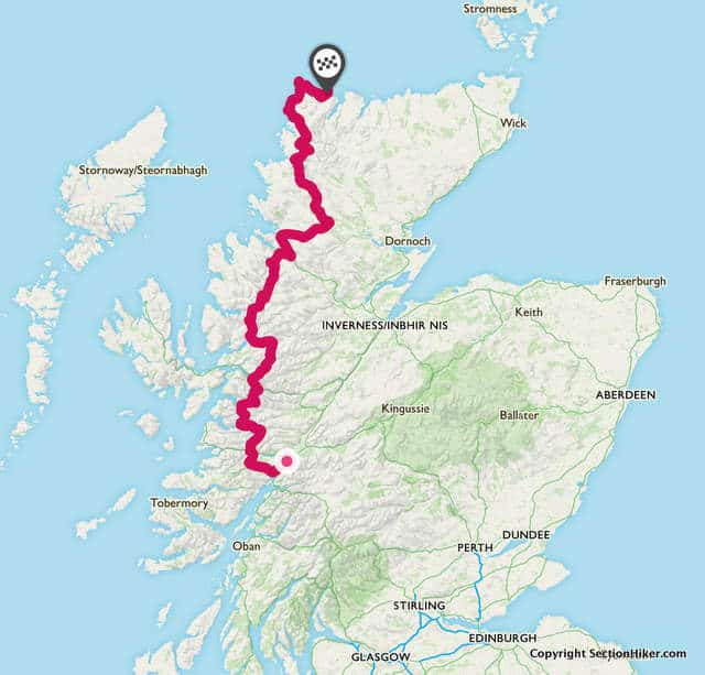
The Cape Wrath Trail is considered the hardest hiking route in the United Kingdom. Located in Scotland, it runs from Fort William, through the Highlands and Western Scotland, to the lighthouse at Cape Wrath, the northwestern-most point of Scotland. Approximately 230 miles in length, most people take 2-3 weeks to backpack the trip. Technically, the Cape Wrath Trail is not a trail at all, but a route, meaning that you can walk from one end to the other any way you like. This gives hikers a fair amount of leeway where they hike and the mountains and side trips they take in along the way. There are many famous mountains along the west coast of Scotland, well worth climbing, if the weather cooperates and you like mountain views. 
While there are guidebooks available and even maps where people hike, the Cape Wrath Trail is unmarked and unblazed, requiring good navigation skills to complete. More often than not, people walk some of the way on old drover’s roads called Hill Tracks, estate roads, and old paths, although there are times when you will hike cross-country over miles of grass tussocks, heather, and bog. Previous Scottish hillwalking experience is definitely an asset and a high degree of self sufficiency is required. Why would one ever want to hike a route like this? It’s in Scotland for one, which is simply a magical place to backpack. Mountainous, wild, and remote, you can travel for days without seeing a soul. Planning your own cross country route is also a fun, if time-consuming process, and adds to the pleasure of journey. Finally, hiking the Cape Wrath Trail gives you the opportunity to navigate a wild route for hundreds of miles without worrying about private property boundaries and other hassles, because walkers can hike where they want in Scotland, one of the few countries in the world that has right-of-way laws for that purpose. The freedom to roam…that’s freedom. 
But the Cape Wrath Trail is challenging for all the reasons that make backpacking in Scotland challenging:

Thankfully, there are no bears or wild animal to worry about, although bloodsucking midges are a hazard depending on the time of year, and Lyme disease carrying ticks are on the rise. While you’ll probably wild camp out most of the time. There are streams and lochs everywhere and water is never is short supply. There are also outbuildings called Mountain Bothies that dot the countryside, often donated by farms and estates, for walkers to shelter in. They usually have a stove or fireplace inside and I have friends who carry lumps of coal on their backpacking trips when they plan a stay, since there’s so little little firewood available nearby. Still these plain building provide welcome shelter in poor weather and make a nice spot to get out of the wind and rain for lunch when you pass by during the day. 
If you’re not from Scotland, your biggest challenge is likely to be understanding the thick Scottish accent and unfamiliar vocabulary used by locals in local shops and pubs. People tend to polite and welcoming in rural Scotland and as long as you mind your manners, you can expect warm hospitality. The best time to hike the Cape Wrath Trail is mid-May to early June before the midges come out (thanks to Alan Sloman, for this piece of advice). If you’ve never backpacked in Scotland, hiking from the west coast to the east coast of Scotland in the Annual TGO Challenge is good preparation for planning and hiking a Cape Wrath route of your own. I completed the Challenge in 2010 solo, and again 2013 with friend Martin Rye, and plan to hike the Cape Wrath Trail by myself in 2018. For more information about the Cape Wrath Trail, here are a few good links and references:
from http://sectionhiker.com/hiking-the-cape-wrath-trail/ 
My boots hadn’t frozen overnight, which meant that my Sawyer water filter was probably still good (they’re wrecked if frozen.) Freezing rain had fallen overnight though and I knew I’d probably get soaked, brushing up against wet spruce on the side of the trail. With bright sunshine and temperatures in the low 60’s, I wasn’t that worried about hypothermia or the fact that my insulated boots were soaked from a stream crossing gone bad the previous day. My biggest concern was the softening snow conditions and whether I’d be postholing despite wearing snowshoes. I’d set out the day before on an 13 mile loop through Carrigan Notch deep into the heart of the Pemigewasset Wilderness, to the headwaters of the East Branch Pemigewasset River near Stillwater Junction. It being late April, I expected some lingering snow, but not quite as much as I experienced. I’d brought snowshoes, of course, but hadn’t expected to need them for 13 continuous miles. It’s difficult to predict what the snowpack is going to be like in the more remote regions of the White Mountains in spring without eye witness reports, and I guess it’d been optimistic to think that three weeks of 60 degree days would have made much of a dent in the snow pack. The area I hiked into is historically called Livermore, an unicorporated civil township and ghost town, bordered in part by Sawyer River Road, Mt Carrigan, Mt Lowell, the East Branch of the Pemigewasset Wilderness and Mt Bemis. The Livermore Wikipedia page is quite informative. 
I’d parked my car the previous morning at the bottom of the Nancy Pond Trail on Rt 302 and hiked a mile south to Sawyer River Road, which was still gated for winter. I then hiked two miles up icy Sawyer River Road in microspikes to the Signal Ridge Trail and snowshoed to the Carrigan Notch Trail, another 1.7 miles farther along. 
Conditions were sloppy. The snow was soft and saturated with water, but it still held my weight as long as I stayed on the monorail. Monorail is a layer of snow and ice that looks like a balance beam in the middle of a trail. It forms when thousands of hikers hike a trail in winter and pack it down. In spring, the sides melt off first leaving the center firm. If you fall off the center and there’s still snow on the sides of the monorail, you invariably posthole in the softer snow, which gets exhausting fast. The stream crossings were running a bit high, but I sloshed through wearing my snowshoes in my waterproof insulated winter boots. Following the trail was another matter and I lost it a few times before finally coming to the Carrigan Notch Trail junction. This trail travels along a steep mountain pass between Mt Carrigan and Mt Lowell. I’d hiked about half of it before when I bushwhacked a subpeak of Carrigan known as Vose Spur, but never beyond it. This time, I’d hike to height of land and back down the other side. 
The Carrigan Notch Trail was a mix of mud and wet snow, deep enough to require snowshoes. I kept on my snowshoes the muddy spots so I wouldn’t have to keep taking them off and putting them on. Someone had recently hiked up the trail, also in snowshoes and I wondered if I’d run into them. I still hadn’t seen a soul and wouldn’t during this entire trip. It started to rain as I approached the Pemigewasset Wilderness Boundary which starts at height of land, the high point of the pass, that marks the boundary between two watersheds. The snow deepened significantly there, but I was headed downhill and made great time. Route-finding was surprisingly easy, despite the fact that the blazes cease when you step into many White Mountain National Forest Area Wilderness Areas and the snow cover occludes most evidence of a trail. However, I knew from past experience that the trail would be very difficult to follow in snow near its junction with the Nancy Pond Trail. This area is a virtual archipelago of streams and bogs with virtually no trail blazes and I’d gotten lost here before on another similar backpacking trip in spring 2014, necessitating an early exit. I’d come better prepared this time for extreme route finding, bringingGuthook’s NE Hiker GPS App on my iPhone, which has all of the trails in the White Mountain Guide. I figured this would be the ultimate test of its value, in the hardest area of the White Mountains to find the trail. It proved to be invaluable. Stay tuned for a complete product review in the next week or two. 
I turned onto the Nancy Pond Trail, about halfway through my hike. It was close to 3:00 pm and I’d started to think about where I’d camp for the night. It looked like I’d be sleeping on the snow pack, but I was prepared for that. Following the Nancy Pond Trail was a breeze compared to that bottom section of the Carrigan Notch Trail, even without much blazing. The snow was getting progressively deeper however and the stream crossings wider. In the end, I decided to camp near the last stream crossing before the 1.7 mile climb up to Norcross Pond since it was near water and in a relatively flat area where I could find a good place to camp. I could have continued to a spot I’ve camped at before at Norcross, but I wasn’t psyched about the climb and doubted that there would be any good campsites along the way. That was indeed true, as I found out the next morning. I set up the luxurious Hilleberg Niak tent I was carrying on this backpacking trip, one of the tents I’m thinking about using on the Cape Wrath Trail in Scotland in May 2018. It’s virtually freestanding, so very easy to pitch on snow. 
I filtered some water, made dinner, hung my Ursack, and read for a while before going to sleep. The forecast had called for nighttime temperatures in the high 30’s and I was geared up appropriately with my XTherm sleeping pad and a 20 degree quit. The next morning, I had a cold breakfast, just walnuts and raisins washed down by a liter of cold water. I wanted to get on the trail and figured I’d take a break at Norcross Pond and cook up a proper breakfast there. The snow was soft enough that I postholed in my snowshoes as I climbed up to Norcross Pond. The trees were also sopping wet from the freezing rain overnight, so I put on a rain coat to keep as much cold water off me as possible. My pants got soaked, but my legs were generating a lot of heat climbing up hill and I knew my pants would dry quickly as soon as I got to the open area around the pond and sunshine. 
Norcross Pond is a high elevation alpine pond that can be considered the headwaters of the mighty East Branch Pemigewasset River by my reckoning. It is still mostly frozen over but obviously soft, so I didn’t venture out onto the surface. Instead I plunked down on a dry rock at the outlook overlooking The Bonds and cooked up a hot meal, while drying off in the sun. Ah. Little did I know that the hardest part of this hike was about to begin. I has 4.3 miles to go to get back to Rt 302 from Norcross Pond. Route finding again proved difficult because this area is cross-hatched with herd paths and not well blazed. While bushwhacking was an option, I prefer to staying on trails, even when they’re buried under several feet of snow, because they’re less of a chance of falling into a spruce trap. Spruce traps are voids around bushed buried in snow that can trap you, when snowshoeing solo. 
As I was, I was postholing in the soft snow despite wearing snowshoes. There wasn’t any monorail here because this area is not hiked in winter (they aren’t any 4000 footers in the vicinity.) There are big bridges though in abundance and I could detect slight bumps on the surface of the snow where they were, despite the fact that they were buried in 2+ feet of snow. I postholed repeatedly but kept on going, making slightly less than a mile per hour. My pace picked up as the elevation started dropping near Nancy Cascade, a series of rapids followed by a huge waterfall that drops beside the trail. Getting down that section of trail which switchbacks very steeply proved very difficult, again because the snow was so soft and my snowshoe crampons had so little solid snow or ice to grip onto. I ended up descending this section by snowshoeing backwards, a footwork trick I know, where you put most of your weight on the forward crampon under your toes to prevent an uncontrolled slide. That took a while but I made it down in one piece. One slip and I would have plunged downhill into thick brush and trees and probably hurt myself badly. 
After the falls, the rest of the hike out the Nancy Brook trail was fairly routine and more manageable. The streams were running high but crossable without incident. I was pretty zonked after this hike, but still glad I’d taken it on. It was a calculated risk in these conditions, but I felt that the warm weather helped offset the issue of doing this loop solo. from http://sectionhiker.com/backpacking-the-livermore-loop/ 
The Backpack Light 50L ($149) is a frameless ultralight style backpack weighing 34.5 oz (L) sold by My Trail Company, which has started manufacturing the same backpacks and tents that GoLite sold before it went bankrupt in 2014. The Backpack Light 50L reviewed here is virtually identical to the Golite Jam 50, which was a popular ultralight backpack in its day. But there has been a lot of innovation in the ultralight and lightweight backpacking market in the past three years with the widespread of adoption of more durable fabrics, lightweight frames, better ventilation, women’s specific models, etc. So much so, it’s worth asking whether a backpack that hasn’t been noticeably changed in three+ years is as good a value today as it was then. Let’s take a closer look at the Backpack Light 50L. Specs At a Glance:
Main Compartment and Storage CapacityThe Backpack Pack Light 50L has a large main compartment for storing your gear which closes with a draw string on the top. The size of the main compartment can be compressed bringing the total pack volume down to 20L so the pack can also be used for day hiking. I explain this further below. I checked with My Trail Company and their 50L volume measurement includes the space in the extension collar that rises above the shoulder straps. The inside of the main compartment has a separate hydration pocket with a center hook for hanging a water reservoir. There are two hydration hose ports as well, above and outside of the shoulder straps. The main compartment has a narrow pocket that holds a thin removable foam pad, which could be used to store maps, although they would be very hard to access if your pack is packed. There’s also a zippered rear pocket, good for storing small or loose items like layers that you want easy access to during the day. It’s large enough to store a puffy jacket or your rain gear and smaller items. The rear pocket does not have a drain hole however and is not designed for storing wet gear. 
The Backpack Light 50L has two side mesh water bottle pockets that have Dyneema reinforced fabric at their base, but are not very well protected on the sides. I’d advise you to be careful with these pockets because the mesh covering them isn’t that durable. The pockets are reachable while wearing the pack and I can get bottles out of them and back in again. The bottom side compression strap runs just above the opening of the side pocket, so it can get in the way of putting bottles back into the pack while walking if it’s not snugged flush against the pack. The side compression strap does not run through the side pocket or outside of it, a common feature on many other packs. The hip belt has two zippered pockets, one on each side, that are faced with the same lightweight mesh used on the outside of the water bottle pockets. I’d caution you about the durability of these as well. Each pocket has a second inner pocket, also mesh, that you can use to store smaller items. The inner pockets are not zippered but held shut with elastic. 
Compact 20L ModeThe Backpack Light 50L has a plastic hook and loop system at the base of the pack that lets shrink the volume of the main compartment, effectively bringing the back of the pack closer to the front. This is good when you want to carry less volume and to shift the contents of of pack closer to your back. I never use a backpack this small for day hiking, but it’s a nice to have, especially for traveling when you want a frameless pack that is easily resized for plane travel and day time touring. External Attachment and Compression SystemThe pack has two ties of size compression straps that open with quick release buckles and are convenient for securing long items, like snowshoes to the side of the pack. The straps can also be run across the back of the pack, if you want to secure gear there, although this will make the zippered external rear pocket awkward to access. There’s a top compression strap that runs over the top of the extension collar and provides very good top compression. You just need to be careful not to over tighten it because it can cause the back of the pack to barrel into your back. The same holds true with the side compression straps is you try to “jam” too much into the main compartment. 
The Backpack Light 50L also has a pair of ice axe loops and two elastic shaft holders, a nice detail that’s missing from many packs. Backpack Frame and SuspensionThe Backpack Light 50L is basically a frameless pack. While there is a removable foam sheet behind the shoulder straps to protect your back from sharp objects in the interior, it’s quite flexible and provides very little structural support. The foam pad also stops at the top of the shoulder straps, while the load lifter straps are anchored above them on the fabric extension collar and not to a frame element. That’s really not the best spot for them to be effective, especially if the extension collar has a lot of slack in it and it’s not stuffed with gear. 
The back of the pack is covered with a strip of spacer mesh to help wick away back sweat, but the pack rests flush against your back and doesn’t provide much airflow. There’s no lumbar padding, although non-adjustable hip belt stabilizer straps are sewn to the bottom corner of the pack at the same point where the shoulder straps connect, which dampen sway with heavy loads. While the hip belt wings are sewn to the pack, they have big cutouts in them and buckle easily under quite moderate loads. I’d only rate this pack for a max load of 20-25 pounds and the company’s rating of 40 pounds defies explanation. The Backpack Light 50L would really benefit from plastic inserts where these holes are, to stiffen it up, and prevent hip belt collapse. 
Both the shoulder pads and hip belt are very lightly padded with spacer mesh on the interior, to wick away perspiration. The hip belt has a thick plastic buckle and you pull back on the webbing to tighten. The shoulder straps have horizontal hose keeper straps, but lack any other attachment points for accessory gear and pockets. There is a whistle on the sternum strap clip, which sides up and down on a track. AssessmentThe Backpack Light 50L is a pretty so-so backpack by today’s standards for lightweight backpacks and what was once a cutting edge ultralight backpack now seems dated. While My Trail Company disavows any relationship with GoLite, it’s pretty clear that the Backpack Light 50L is an almost exact replica of the GoLite Jam. My wife still owns and uses a Jam and the two packs are almost identical. 
Ancient history aside, how does the Backpack Light 50L perform? I think it’s a comfortable pack for carrying up to 20-25 lbs loads that fill up to main compartment to about shoulder height. If you add much more weight, the back of the hip belt collapses because it has holes cut out of it to enhance ventilation, causing more load to shift the shoulders. If you tightly stuff the extension collar with bulky gear, the pack becomes increasingly ungainly to manage, and will barrel into your back because it’s essentially frameless. You might be able to up the weight you can carry a bit by rolling up a RidgeRest and using it as a virtual frame to increase the pack’s stiffness, but doing so will use a huge amount of interior space with marginal benefit. I’d also be concerned about the durability of mesh side water bottle pockets and hip belt pockets. There would be much more durable if they were partially or completely covered with solid panels. As they are, I’d expect them to get torn up pretty fast when they contact the ground or aggressive vegetation. I’ve destroyed countless backpacks this way and they’re a reason why most lightweight backpack makers have switched to solid pockets on more vulnerable areas. Net net, I think the Backpack Light 50L could be an immensely better pack with a few select design changes, but I’d give the current version a pass unless you get it at a discount. Even then, I’d recommend that you take a look at other budget-priced backpacks in the same $150 range, including the Osprey Talon 44, the Mountainsmith Scream 55, the Klymit Motion 60, and the Granite Gear Virga 2. The backpack market hasn’t stood still in the past three years and there are a lot more lightweight backpacks available today that have better frames and features than the Backpack Light 50L. Likes:
Dislikes:
Disclosure: My Trail Company provided the author with a sample backpack for this review.
from http://sectionhiker.com/backpack-light-50l-review/ 
Satellite imagery is a powerful source of information for planning backcountry routes but it takes practice to interpret what you’re looking at, and whether it depicts features you can use to make your route easier or whether you should avoid them. The best way to view satellite imagery is side-by-side with a topographic map of the area you’re interested in. I use a free online navigation planning tool called Hillmap.com is ideal for this purpose because it keeps both views of the same area in synch with one another. For example, if I’m viewing a topographic map that has a river and a highway drawn on it (above left), I can easily correlate that with the imagery associated with them (above right.) I can also draw a route on a topographic map and have it mirrored on top of the satellite image. 
If I drill down further into the satellite view (left above), I can make out three landscape features not shown on the topographic map of this area.
With practice, you can teach yourself how to recognize a wide range of landscape features by matching what’s shown on topographic maps and what’s not. Features like cliffs, ravines, landslides, trails, paved roads, dirt roads, rivers, streams, open fields, potential property boundaries, buildings, bridges, dams, bogs, and so on. Some of this information can be quite useful, especially if you don’t have up to date topographic maps or road maps for backcountry areas, something that’s quite common in the more rural areas of the backcountry. Like all maps and mapping data sources, you need to be a little cautious about the completeness and age of the satellite imagery data you use to plan routes in navigation planning tools. For example, the satellite imagery shown in these examples is labelled in Hillmap as being sourced in 2017, which hardly seems likely, given that it’s still winter in this area and much of it’s still covered in snow. When in doubt, use Google to find trip reports or other data sources, including paper maps, if you require more information. from http://sectionhiker.com/how-to-interpret-satellite-imagery-for-backcountry-navigation-using-hillmap-com/ 
The Gossamer Gear Silverback 50 Backpack ($260) is an ultralight style backpack made with heavy duty fabrics for off-trail and wilderness trips that rip up packs made with lighter weight fabrics and external mesh pockets. Weighing 37.4 ounces, the Silverback 50 can carry up to 35 pounds comfortably and endure harsh treatment making it fairly unique as a durable lightweight backpack. For more information about this new pack, check out my recent Silverback 50 gear review. Deadline to EnterThe deadline to enter this raffle is Tuesday, April 25, 2017, at midnight PST.
To EnterTo enter this random raffle for a chance to win a free Gossamer Gear Silverback 50 Backpack, answer the following four questions in a comment below:
Incomplete or unintelligible answers will be disqualified. Brevity is appreciated. Example ResponsesExample 1:
Example 2:
Example 3:
Please answer the four questions in a comment below to enter.
from http://sectionhiker.com/enter-for-a-chance-to-win-a-free-gossamer-gear-silverback-50l-backpack/
Simple Fly Fishing: Techniques for Tenkara and Rod and Reel is a beautiful coffee table book full of gorgeous trout photos, exotic fly fishing locations and anecdotal stories about fly fishing with the world’s greatest fishing guides. The authors, Yvon Chouinard, founder of Patagonia Inc, Craig Mathews, Mauro Mazzo, and illustrator James Prosek go to great lengths to explain how simple, economical, and egalitarian Tenkara fly fishing is compared to the elitist vocation of fly fishing as they describe their fishing expeditions jetting around the world, no doubt on the Patagonia corporate jet. But if the goal is to inspire by example, this book is a complete failure. Tenkara fly fishing isn’t nearly as difficult or technical as the authors make it out to be, nor is regular fly fishing with a rod and reel. Get a friend to lend you a rod and some flies and show you the ropes. You’ll be fishing in an afternoon. Or if you want to get serious, take a three hour lesson from a local river guide, buy a basic rod and tackle, and you’ll have all the knowledge and skills you need to start catching fish. What’s Simple Fly Fishing about? I’m honestly still trying to figure that out. It’s definitely NOT a book for beginner fly fisherman or anyone interested in learning the Tenkara or rod and reel fly fishing basics. The thing that makes this book so curious is the authors’ side by side comparison of Tenkara and Rod and Reel fishing techniques. They advertise their disdain for those elitist rod and reel fly fisherman who emphasize long casts over close-in fishing. The reality is that most fish are caught within 25 feet of where you’re standing no matter what kind of equipment you use. But you get the impression that they’re trying to convince their country club buddies that Tenkara is a worthy pursuit because you can use the same representational flies, match the hatch, and wiggle the line the same way as with a rod and reel. That’s all true, but the tone makes you wonder who the intended audience for this book really is. Simple Fly Fishing is not a complete waste of paper. There is some good information about the lifecycle of different bugs, trout behavior, and practical information (towards the end) about how to fish different stream habitats. But there are many places to obtain the same information more concisely on the Internet for free. If you’re looking for a simple introduction to a simpler way to fly fish, I’d recommend looking elsewhere. Disclosure: The author paid for this book with his own funds.
from http://sectionhiker.com/simple-fly-fishing-anything-but/ |

ABOUT MEHello my pleaseure to introduce myself, I am Jose Johnson. I am 26 years old from Monroe, LA. I love to got for hikings with my friends on holidays. Archives
April 2019
Categories |


 RSS Feed
