|
A 2-3 day, 22 mile scenic loop that travels up the Dry River Valley, climbing the Oakes Gulf headwall, to a set of alpine lakes at the foot of Mt Washington. From here, hikers climb 4 four thousand footers in sequence: Mt Monroe, Mt Eisenhower, Mt Pierce, and Mt Jackson, before descending the Webster Cliff Trail back to Crawford Notch. This route has close to 10 miles of above-treeline hiking and unparalleled views of Mt Washington, the Dry River Wilderness, and Crawford Notch. Rating/Difficulty*****/4 out of 5 Distance/Elevation Gain22 miles w/6000′ of cumulative elevation gain White Mountain 4000 Footers
Recommended Duration2-3 days Seasonmid-June thru October Permits RequiredNone. RegulationsBackcountry Camping Regulations for the White Mountain National Forest, specifically no camping above treeline where trees are less than 8′ in height (except on two feet of snow.) A substantial portion this route passed through the Dry River Wilderness Area. Please observe all wilderness area restrictions. Trailhead DirectionsWebster Cliff Trailhead Directions (44.10148, -71.23164) – Parking is available for a few cars across Rt 302 from the trail head. NH state law requires that all tires be off the pavement. This is a busy trailhead that has a lot of traffic passing by, so parked cars are generally safe. Trail SequenceThe route follows the following trails in sequence. Refer to AMC White Mountain Trail Map 1 – Presidentail Range (2017 ed), which is the best waterproof map available for this region, although I’d recommend buying the complete AMC White Mountain Waterproof Map Set (2017 ed) rather than one map at a time. More detailed trail descriptions can be found in the AMC White Mountain Guide (2017 ed), which is considered the hiking bible for the region. Take photos of the pages using your phone for easy reference, instead of carrying the entire book with you on hikes.
Scenic HighlightsThe following list provides cumulate distances on the route to each view or landmark.
Camping/Shelter Options
WaterNatural water sources are plentiful in the White Mountains although you may need to descend to them from ridgelines along side trails if you run short. The longest stretch of dry trail on this route runs from the Nauman Tentsite and Mizpah Spring Hut to the base of the Webster Cliff Trail in Crawford Notch. However, when the AMC Huts are in season, anyone can stop in and resupply their water for free from the small sink located near the hut kitchen. In any case, carry a detailed topographic map with you and don’t rely on the overview map provided with this trip description to find water sources. I also recommend purchasing the Presidential Range Map in Guthooks Guide’s White Mountains and New England Trails Smartphone App (IOS, Android) which is a GPS guide to all of the trails, trailhead, shelters, campsites, views, and water sources in the White Mountains National Forest. I use it all the time and it is much more complete and current than using the maps bundled with theGaia Smartphone App. Weather CautionsThis route is sensitive to seasonal and weather conditions which can make it hazardous. There is a river ford at the Dry River Shelter that can be hazardous in high water. Wait a few days for water levels to drop after a significant rainfall (more than 1-2″) before hiking the Dry River Trail. The second half of the route from Lakes of the Clouds to Crawford Notch has close to 10 miles above-treeline travel and is hazardous to hike if thunderstorms or high winds are forecast. The top of the Dry River Trail in Oakes Gulf is usually clear of winter snow by mid-June, but patches of snow may linger into July. On the TrailCross Rt 302 and begin the trip on the Webster Cliff Trail. Pass the first Saco River Trail junction at 0.2 miles on your left (running north) and continue to the second one at 0.3 miles on your right (running south). Follow the Saco River Trail and proceed for 1.7 miles through forest, parallel to the Saco River. This is section of the river is near its headwaters at the top of Crawford Notch, so the stream is quite small here. On your left you’ll soon see the tail of a large land slide that fell from Webster Cliff, which towers above, though hidden by the tree canopy. Turn left at the junction with the Dry River Trail, heading in an easterly direction. You’ll be on this trail for the next 9.1 miles until you reach the AMC’s Lakes of the Clouds Hut. The Dry River Trail is in the Presidential-Dry River Wilderness, and the trail can be challenging to follow in places because it’s purposefully not as well maintained or signed as other trails.
The trail also suffered major damage from Hurricane Irene in 2011 which resulted in numerous landslides and stream bank erosion, that are still in evidence today. While the trail has been rerouted over and past the landslides (that wiped it out), the newer segments of trail aren’t as well marked by traffic as the older sections that were untouched by the storm. Don’t let this deter you from backpacking this route, especially since this is one of the most remote (lost world) spots in the White Mountains, despite its proximity to Mt Washington and Crawford Notch. 
In 1.2 miles, you’ll come to the Dry River Suspension Bridge and cross over it to the other side of the river. This is a good spot to linger and take in the sublime magnificence of the Dry River, its huge boulders, eddies, pools, and rapids. You’ll catch glimpses of the river as you hike upstream, from the river’s edge and high above it, looking down its steep side slopes. Fly fishermen will recognize all the signs of a fun river to fish. Just make sure you have a New Hampshire fishing license and adhere to daily limits, since the native trout are on the small side and subject to enormous environmental pressure in this small watershed. 
Finish crossing the bridge and turn left at the end, hiking up the Dry River Trail towards Mt Washington. After 1.2 miles, you’ll pass a sign to the Mt Clinton Trail on your left (and stay on the Dry River Trail). Hiking the Mt Clinton Trail requires a ford across the Dry River followed by a climb to the Mizpah Hut, below Mt Pierce, formerly named Mt Clinton. The Mt Clinton Trail was for many years one of the hardest trails to follow in the White Mountains due to lack of maintenance. It has recently been taken over by a new trail adopter, who I’m told has made it easier to follow. Continue along the Dry River Trail. In 2.0 miles, you’ll come to a trail junction with the Isolation Trail, which provides access to Mt Isolation on a less travelled route. Pass through the junction and continue on the Dry River Trail, continuing straight past the Mt Eisenhower Trail on your left, 0.3 miles farther along. The Mt Eisenhower Trail also requires a ford, before climbing to the Crawford Path below Mt Eisenhower. In 0.2 miles, you’ll ford the Dry River to the north side, near the Dry River Shelter #3, shown below. If you don’t have previous experience fording rivers, this crossing can be a little intimidating. But it’s not a wide crossing or a high volume crossing (except after significant rainfall) because it’s so high up the river valley, where there’s less water flowing into the watershed. You can’t rock hop it though. Unbuckle your back pack belt so you can jettison your pack if you fall (and it fills up with water dragging you under) and walk across. I’d recommend keeping your boots or shoes on to protect your feet and ensure solid footing as you cross. 
In 0.7 miles, you’ll arrive at the Dry River Shelter #3, which is a good place to call it a day and rest before the climb up the Oakes Gulf headwall at the top of the Dry River Valley. There’s limited space for tents here, but the shelter is still in decent shape, and there are lots of trees around to hang a hammock. Dry River Shelter #1 and #2 were removed years ago and #3 will be next when it’s in need of major repairs. Though controversial, the USFS is removing lean-tos in Wilderness Areas to comply with the Wilderness Act, which prohibits most man-made structures in these areas. 
When you leave Dry River Shelter, the trail enters a heavily wooded area called Oakes Gulf which is subject to blowdowns and lingering snow that can make the trail hard to follow, particularly in spring before the trail crews have visited. Snowmelt also often flows down portions of the trail which can be muddy too, early in the season. The trail climbs the headwall until it reaches height-of-land on the Southwest shoulder of Mt Washington. After leaving the Dry River Shelter, this is a not-so-insignificant 2400′ ascent, so take your time. Oakes Gulf is a sibling to the other great ravines that surround Mt Washington, including Tuckerman Ravine, Huntington Ravine, The Great Gulf, and the Ammonoosuc Ravine. They all have their own headwall trails too. 
When you crest the headwall, you pass a large cairn. Just beyond it are two alpine tarns called the Lakes of the Clouds, and beyond them, the AMC Lakes of the Clouds Hut. Even if you’re not a guest, I’d encourage you to pop into the hut for a visit. There’s water available here, snacks, bathrooms, and lots of information scattered around. This hut houses up to 96 guests per night and serves them two meals per day, so it’s pretty cushy. There are also weather instruments in the hut and an updated forecast posted which are worth checking before you proceed on the second half of this journey. If the wind is blowing over 40 miles per hour at the hut, you’re going to have a long day hiking down the Southern Presidential Range back to Crawford Notch. If there are thunderstorms in the area, I’d recommend descending off the ridge completely because it’s completely exposed without any cover and there’s a very real risk of being struck by lightning directly or indirectly by ground current transmitted through the rocks. I don’t mean to scare you off this route, but it is important to plan this hike around a few good weather days, both in the Dry River Valley and up above treeline. The views are also much better. 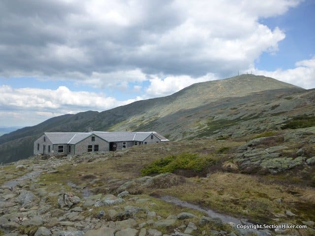
If you do need to boogie off the ridge, it’s best to head down the west side rather than the east because it has better road access and requires a shorter hike out if you decide to bail. The best west-side escape routes are the Ammonoosuc Ravine Trail, the Edmands Path, and the Mizpah Cutoff/Crawford Path. There’s also parking at the end of all of these trails if you decide to spot a car there. 
Leaving the hut, you’ll follow the Crawford Path 0.1 miles to the Monroe Loop trail, which climbs Mt Monroe and a sub-peak behind it, before rejoining the Crawford Path. Monroe an easy 350′ climb from the hut, despite the fact that it’s the fourth highest 4000 footer, at 5384′. That’s the beauty of a ridgeline walk and the secret to hiking multiple 4000 footers on one hike. Once you climb a ridgeline, you can pick off one peak after another, on the same hike, with relatively little incremental effort. Many of the 4000 footers are on common ridgelines and its a thrill to bag several on the same walk. If you’re a purist, there are other White Mountain peakbagging lists that only credit you one peak per hike, so you can only count one at a time. Those are fun too! 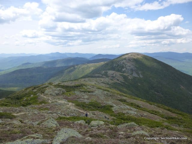
The Monroe Loop Trail rejoins the Crawford Path in 0.7 miles at a well-marked junction. Follow the Crawford Path (heading southwest) for 2.2 miles to the Eisenhower Loop Trail, which climbs another 350′ to the large rock cairn that marks the Eisenhower summit. Mt Eisenhower is named after the former US President Dwight Eisenhower, presumably because they share the same bald dome. Continue past the Eisenhower cairn and rejoin the Crawford Path and follow it 1.7 miles to the summit of Mt Pierce, a rocky summit which juts above treeline. The views are almost continuous along this stretch, so take time to stop and day-dream. From the just below the summit of Mt Pierce, take the Webster Cliff Trail 0.9 miles to the Mizpah Hut, where you can also pop in for water, a bathroom break, or refreshments. Baked goods and left overs are usually available for purchase in the huts during the day and can provide a welcome break. Hint: buy the fresh-baked bread that’s often available. While a big slice of bread costs money, the butter is often free, so lather it on for some extra calories. The AMC’s Nauman Tentsite is situated next to the Mizpah Spring Hut and is the only designated campsite along the Southern Presidential Ridge where you can camp overnight. The tentsite is overseen by a caretaker in season and a small fee is charged. 
Continue southwest down the Webster-Cliff Trail to Mt Jackson which is another knobby peak that just pokes above treeline. Continue southwest along the Webster-Cliff Trail for 1.3 mile to Mt Webster. DO NOT take the Jackson Branch or Webster Branch Trails from Mt Jackson, but remain in Webster-Cliff Trail. Mt Webster is at the top of the Webster Cliff, along the east side of Crawford Notch. To your immediate west, you can see the slide scarred east face of Mt Willey on the other side of a great abyss, as well as the valley below. 
Follow the Webster-Cliff Trail, turning left (south) onto it after Mt Webster, and hike along the top of the cliff, before descending back to the valley floor. This section has several rocky scrambles, so take your time descending and don’t hesitate to scooch down on your butt if circumstances warrant it. After 3.4 miles, you’ll return to the valley floor and the start of your journey. Safety DisclaimerThis trip plan can not alert you to every hazard, anticipate your experience, or limitations. Therefore, the descriptions of roads, trails, routes, shelters, tent sites, and natural features in this trip plan are not representations that a particular place or excursion will be safe for you or members of your party. When you follow any of the routes described on SectionHiker.com, you assume responsibility for your own safety. Under normal conditions, such excursions require the usual attention to traffic, road and trail conditions, weather, terrain, the capabilities of your party, and other factors. Always check for current conditions, obey posted signs, and Backcountry Camping and Wilderness Area Regulations. Hike Safe and follow the Hiker responsibility code. Disclosure: SectionHiker.com receives affiliate compensation from retailers that sell the products we recommend or link to if you make a purchase through them. When reviewing products, we test each thoroughly and give high marks to only the very best. Our reputation for honesty is important to us, which is why we only review products that we've tested hands-on. Our mission is to help people, which is why we encourage readers to comment, ask questions, and share their experiences on our posts. We are independently owned and the opinions expressed here are our own.The post A Southern Presidential Loop Trip Plan: Backpacking the 4000 Footers Guidebook appeared first on Section Hikers Backpacking Blog. from https://sectionhiker.com/a-southern-presidential-loop-trip-plan-backpacking-the-4000-footers-guidebook/
0 Comments
“These aren’t 20 mile per hour winds,” I told Eliot, as we started climbing the Crawford Path up to the Southern Presidential Range, just south of Mt Washington in New Hampshire. Our destination was Mount Pierce and Mt Jackson, two 4000 footers, both with above-treeline summits. I could tell that the winds were stronger because they were pushing me off-balance as I walked, an indication that we were probably experiencing winds closer to 40 or 50 miles per hour. A minor, but messy storm system was forecast to pass overhead during our hike, dumping 3-7 inches of snow on us during the day, with a chance of sleet as well. But our route to Pierce and Jackson was fairly well protected by tree cover, so we decided to attempt Pierce first and then loop around to Jackson if we felt that the conditions were safe.I wasn’t that worried by the wind or the oncoming snow because I knew we were well equipped and temperatures were hovering near 30 degrees, greatly reducing the risk of windchill and frostbite for short periods of exposure. Nearby Hikes:
We all carried face masks and goggles, heavy mittens, and traction in the form of microspikes and crampons. We decided to leave our snowshoes behind however, because we knew these trails were well packed out, since they’re two of the more popular winter peaks to climb from Crawford Notch. There’s a local newsgroup called NewEnglandTrailConditions that lists trail condition reports submitted by hikers and is quite useful for winter trip planning. 
We started up the Crawford Path, which is the oldest continuously maintained trail in the United States. It climbs gradually to Pierce, climbing about 2300′ in 3.1 miles. The trail was well packed out and we just wore microspikes for traction. The wind howled high overhead in the trees and it started to snow much more heavily as we approached the peak. We’d been climbing in mid-layers to reduce sweating, but the snow was making our clothes wet, so we layered up again with hard shells to stay warm and dry. When we arrived near the summit of Pierce, we suited up for full exposure in the trees with balaclavas, face masks, and goggles. Eliot and I were with another strong hiker named Caleb, who rounded out our party. There’s a short stretch of above treeline exposure from the protection of scrub to the summit cairn, but the snow was blowing horizontal and covering every bit of exposed skin was the safest and most comfortable option. We all scrambled to the summit which was coated with a thin and slippery layer of ice. The wind was still blowing hard and I could feel it pushing me as I neared the summit cairn. This wasn’t a day to stop and take photos, so we hiked past it without stopping and back down into the protection of the krumholz to consider our next move. We’d passed a trail sign marking the Webster Cliff Trail junction just past the Pierce summit, but it’d been covered in ice and was hard to read. I checked our position on my iPhone GPS (in Gaia) to make sure we’d gotten on the right trail and Eliot checked his compass to make sure we were headed down it in a southerly direction. We all agreed to proceed to our next checkpoint, the Mizpah Spring Hut, where there is another trail junction and trail that could be used as an escape route if we decided not to proceed. The Webster Cliff Trail is bordered by spruce trees and was well packed out except for shallow snow drifts. This section of trail coincides with the white blazed Appalachian Trail and the blazes helped considerably with route-finding in the deep snow. I always get a little thrill when I see AT blazes in winter because they’re usually ankle height instead of their normal head height, due to snow depth. We were literally hiking along the tree tops. 
We’d almost reached the Mizpah Hut when we encountered a huge tangle of blow-downs that blocked the trail. There must have been 40-50 trees down and I was a little surprised that trail crews hadn’t been up to clear them out yet. The scene of destruction is in a Wilderness Area, which might explain it, since chain saws and other mechanized tools are prohibited. If they need to clear the areas with axes alone, it’s going to take a lot of people to clear the downed trees. I was hesitant to lead our tiny group through the downed trees because I was afraid of falling into hidden voids under the snow surface. So we bushwhacked around them and then found an opening that led to the hut, which we ducked behind to get out of the wind. After refueling with food and water, we had another discussion about our next steps. Eliot and Caleb wanted to continue the next 1.6 miles to Jackson, but agreed to turn around if we hit deep snow drifts and started to posthole. 
I was cautious about proceeding due to an experience I’d had many years ago on the southern-most section of the Webster-Cliff Trail south of the Jackson summit, beyond the section we were about the hike down. We’d encountered very deep snow drifts on that hike and had a very hard time making headway, despite having a big group of highly experienced and snowshoe-equipped hikers. Eliot, Caleb, and I had no intention of hiking that section of trail, but I was still concerned that might encounter similar conditions on the section north of Mt Jackson. Eliot switched off with me and took the lead. We passed many postholes, where someone had sunk into soft snow despite the fact that they’d been wearing snow shoes, but they were easy to skirt on the frozen surface. The summit of Jackson is similar to Pierce, and is really just a rocky outcrop sticking above treeline. I scrambled up in microspikes, while Caleb and Eliot put on their crampons for the final ascent up more ice-covered rock. We quickly descended to cover again and headed down the Jackson Branch of the Webster Cliff Trail back to Crawford Notch, the wind still howling overhead. Total Distance: 8 miles with 3000 ft or elevation gain. 
Recommended Guidebooks and Maps:
Written 2018. Disclosure: SectionHiker.com receives affiliate compensation from retailers that sell the products we recommend or link to if you make a purchase through them. When reviewing products, we test each thoroughly and give high marks to only the very best. Our reputation for honesty is important to us, which is why we only review products that we've tested hands-on. Our mission is to help people, which is why we encourage readers to comment, ask questions, and share their experiences on our posts. We are independently owned and the opinions expressed here are our own.The post Climbing Mts Pierce and Jackson in February appeared first on Section Hikers Backpacking Blog. from https://sectionhiker.com/climbing-mts-pierce-and-jackson-in-february/
Sleeping bags are still the most popular nighttime insulation option with backpackers because they’re warmer in cold, damp, or drafty weather, especially below freezing. While mummy bag designs still prevail, there’s a lot more variety in the types of sleeping bags that have become available in the five years, including ones designed for side sleepers and women’s specific sleeping bags. Is it worth buying a women’s specific bag? You betcha, but they’re not as widely available as sleeping bags for men. When choosing a sleeping bag for backpacking, you want one that’s warm, lightweight, and highly compressible since you’re going to have to haul it in a backpack. Sleeping bags insulated with 800, 850, 900, and 950 goose or duck down are the best in terms of warmth by weight, but you’ll pay a premium at the top end. Fit is also important, both width and length, especially if you’re a woman, short, or have a smaller build. If a bag is too large, it will feel colder than one that fits closely, since your body needs to work harder to fill the extra space with hot air. Women also require more insulation than men because they have less body mass to generate body heat. Add another 10 degrees if you’re female and decide to buy a “unisex” sleeping bag instead of a women’s specific bag. Women also tend to have colder extremities, like feet, hands, and heads, and require more insulation in those areas. They also have narrower shoulders and are predominantly shorter, requiring sleeping bags that are cut differently than their male counterparts. Here are our top 10 sleeping bag tips, including men’s and women’s specific bags. 1. Feather Friends Flicker UL 20 – Unisex/Men’s
The Feathered Friends Flicker UL 20 is a highly versatile hoodless sleeping bag that’s ideal for side sleepers who find a mummy bag too constraining. In cooler weather, the Flicker functions as a full center-zip mummy sleeping bag with a heat-saving down-filled draft collar that drapes around your neck and over your shoulders to seal in heat. It has a drawstring footbox can be cinched tight on cooler nights or opened up to vent the bag if you’re too warm. Unzipped, it can be flipped over on warmer nights and used like a quilt or a blanket, since the footbox opens completely.
Insulated with 950+ fill power down, the 20ºF Flicker has continuous baffles that let you move the down fill to where you need it. Weighing 26 oz, it’s perfect for cool summer nights in alpine terrain and thru-hikes. 2. Western Mountaineering Versalite 10 – Unisex/Men’s
The Western Mountaineering Versalite is a warm and spacious sleeping bag with plenty of interior room. It has continuous baffles so you can move the down where you need it most, on top on cold nights, and to bottom of the bag on warm ones, thereby expanding its temperature range. A full length zipper makes it easy to vent on warmer nights, while an insulated draft collar seals in the heat. A “flattish” mummy-style hood is also easier to use for side sleepers.
The Versalite is available in three lengths: 5′ 6″, 6′ 0″, and 6′ 6″. Insulated with 850+ fill power goose down, it weighs in at just 32 ounces. It’s available in three lengths, making it ideal for ultralight backpackers who hike in cool mountain climates. Buy at Backcountry.com Buy at Amazon 3. Marmot Phase 20 – Unisex/Men’s
The Marmot Phase 20 is an lightweight sleeping bag for men that weighs just 23.7 oz. It has curved baffles that help prevent down-shift, with a highly breathable and ultralight 10 denier Pertex Quantum shell. An anatomically shaped footbox provides extra warmth where you need it most, while extra baffles in the hood keep your head warm. It has a full-length, locking 2-way zipper with anti-snag slider that can also be opened to vent the bag in warmer temperatures.
The Phase 20 is insulated with 850+ fill power goose down and is available in two lengths: 6′ and 6′ 6″. Buy at REI Buy at Backcountry.com 4. Western Mountaineering Ultralite 20 – Unisex/Men’s
The Western Mountaineering Ultralite 20 is a mummy-style sleeping bag that’s loaded with technical features. It has a built-in draft collar that wraps around your neck and the front of your chest to seal in the heat. Continuous baffles let you shift the down to where you need it the most, either on top in cold weather, or the bottom in warm, while a full length zipper lets you vent it easily. Dual draft tubes seal a no-snag zipper, keeping you warmer, while the low “flattish” hood is suitable for back and side sleepers
The Ultralite is available in three lengths: 5′ 6″, 6′ 0″, and 6′ 6″. Insulated with 850+ fill power goose down, it weighs in at just 29 ounces. Buy at Backcountry.com Buy at Amazon 5. Montbell Down Hugger 900 #2 (25 degree) – Unisex/Men’s
The Montbell Down Hugger 900 #2 is a 25 degree sleeping bag with a unique design that literally hugs you when you move around at night, eliminating dead air spots so that your body doesn’t have to heat them to stay warm. The hugging action is realized by integrating a woven fabric “cut on the bias” and orienting the fabric’s threads at 45 degrees to most major seam lines, so the sleeping bag becomes more fluid in nature. The Hugger also features an integrated draft collar, dual draft tubes and locking zipper, which are all features found on premium sleeping bags.
A good choice for side or back sleepers, the Down Hugger 900 #2 is insulated with 900 fill power, water-resistant goose down. It weighs 24 oz and is available in a 6′ length. 6. Feathered Friends Egret UL 20 – Women’s
The Feathered Friends Egret UL 20 is top-shelf technical sleeping bag tailored for the female form that features extra fill in the footbox and around the chest. It also provides more room in the elbows including space to draw your knees up in the bag if you like to sleep that way. The contoured hood opens wide in warmer weather and makes it easy for side sleepers to use, while a two-way zipper makes the bag easy to vent. The Egret has a draft collar to help seal in the heat around your shoulders, with a trapezoidal footbox allows your feet to fall in a natural pose without compressing the sides.
Available in two lengths: 5′ 3″ and 5′ 9″, the Egret UL 20 is insulated with 950+ fill power goose down and weighs just 27 oz. 7. Marmot Phase 20 – Women’s
The Marmot Phase 20 (Women’s) is a female sleeping bag with more insulation in key areas where women experience heat loss. A tapered cut provides a narrower fit at the shoulders and a wider flare at the hips to insure a comfortable fit and maximum thermal efficiency. A shorter 5′ 6″ length helps to avoid cold spots and make certain that your body isn’t working unnecessarily to heat uninhabited areas of the bag.
The Phase 20 is insulated with 850+ fill power goose down that’s been treated with water-repellant coating. Weighing 29 oz, the Phase 20 is ideal for women who want to slash pack weight without compromising on sleeping comfort. Buy at Backcountry.com Buy at Campsaver 8. REI Joule 21 – Women’s
The REI Joule 21 is designed to fit a woman’s body, with increased room at hips, decreased room at shoulders, and extra insulation in critical heat-loss areas such as the feet and hood. It features a double-protection design that combines treated, water-resistant down with waterproof/breathable fabric at the hood, sides and footbox, all areas that are likely to touch a damp tent wall. A contoured hood, insulated face muffler, and full-length draft tube all work to seal in the warmth so it doesn’t escape when you move around in the bag at night.
The Joule is insulated with 700 fill power duck down. It weighs 35 ounces and is available in 5′ 6″ and 6′ lengths. A wider size is also available. 9. NEMO Jam 30 – Women’s
The NEMO Jam 30 is a spoon-shaped women’s sleeping bag with extra insulation in the feet and torso to keep you warm. Ideal for side sleepers, the Jam has front vents, called Thermo-Gills, that let you vent excess heat in warmer weather. A full-length double-slider zipper with snag guard helps to further regulate warmth. A blanket fold at the base of the hood tucks around you neck and helps seal in the heat in colder temperatures, while the hood is large enough to hold a pillow in place when you don’t need to pull it closed in cold weather.
Weighing 35 oz, the Jam 30 is available in two lengths, 5′ 6″ and 6′. It is insulated with 800+ fill power Nikwax water-resistant down. 10. Marmot Xenon 15 – Women’s
The Marmot Xenon 15 is made specifically for women with increased room at the hips, decreased room at the shoulders, and extra insulation in female heat-loss areas. An anatomically shaped footbox with wraparound construction eliminates seams and has extra insulation to keep your feet toasty. The ergonomic hood has extra baffles to reduce heat loss and keep your head warm and comfortable. A “fold down” second zipper lets you to fold down the front of the bag to vent excess heat and makes it easier to get in and out of the bag.
The Xenon 15 is insulated with 800 fill power, water-resistant goose down. It weighs 38 ounces and comes in a 5′ 6″ length. Sleeping Bag Evaluation CriteriaHere is a list of the most important factor to consider when purchasing a sleeping bag for backpacking, so it fits your needs and preferences. TEMPERATURE RATINGS: The introduction of standardized sleeping bag temperature ratings by the outdoor industry substantially improved their reliability. Bags tested with the European Norm (EN) 13537 get two ratings: a Comfort rating and Lower limit rating. The Comfort rating is the lowest temperature at which the bag will keep the average woman (or “cold sleeper”) comfortable, and the Lower Limit rating is the lowest temperature at which the bag will keep an average man (or “warm sleeper”) comfortable. The difference in the Comfort and Lower Limit ratings is usually about 10 degrees, since women feel colder than men when sleeping. If you’re a woman and decide to buy a men’s or unisex bag, get one that’s 10 degrees warmer than you need so you’re comfortable at night INSULATION and COMPRESSIBILITY: High quality goose and duck down with fill powers of 800, 850, 900, and 950 provide excellent insulation by weight and are widely preferred by backpackers and base campers because they’re so lightweight. Some manufacturers only offer down that’s been treated with a water-repellent coating, while others prefer to offer it unadulterated. Down is naturally water-resistant so the jury is still out on whether “treated” down makes a difference in the long-term, since it’s easy to keep your sleeping bag dry with a little care. SIZING: The fit of a sleeping bag is usually measured in terms of length and girth. Girth measures the maximum internal circumference of the bag, usually at the shoulders, hips, and feet. Measure yourself at these points and compare them to the girth to see if the bag will fit tightly or loosely. People with bigger shoulders or sides sleepers tend to feel more comfortable in bags with higher shoulder girths, while women typically need a shorter length bag and a smaller shoulder girth because they have narrower shoulders than men. It’s important to get a bag that minimizes the amount of unoccupied interior space relative to your measurements, so your body has less air to heat up to stay warm. WEIGHT: While gear weight is important, be careful not to sacrifice your comfort by selecting a sleeping bag that won’t keep you warm or dry in the conditions you need it to. When choosing between bags with different outer shell fabrics, consider their breathability, so they will vent perspiration that can degrade your insulation, and whether they have a DWR coating, which can be important if the foot of your quilt gets wet regularly. FEATURES: Most sleeping bags are pretty similar when it comes right down to it, but there are some features that set premium sleeping bags better than non premium bags. These include draft collars, continuous baffles, very high fill-power goose down, non-snagging zippers, draft tubes positioned behind zippers to seal out the cold, ventable foot boxes, and full length zippers that help extend the range of a bag in warmer weather. Check out SectionHiker’s Gear Guides
Written 2018. Disclosure: SectionHiker.com receives affiliate compensation from retailers that sell the products we recommend or link to if you make a purchase through them. When reviewing products, we test each thoroughly and give high marks to only the very best. Our reputation for honesty is important to us, which is why we only review products that we've tested hands-on. Our mission is to help people, which is why we encourage readers to comment, ask questions, and share their experiences on our posts. We are independently owned and the opinions expressed here are our own.The post 10 Best Backpacking Sleeping Bags of 2018 (For Men and Women) appeared first on Section Hikers Backpacking Blog. from https://sectionhiker.com/10-best-backpacking-sleeping-bags-of-for-men-and-women/
The heaviest items in your backpack are water, food, and fuel. They’re called consumables because you use them up as your trip progresses, as opposed to “base weight” which measures the weight of non-consumable items like a backpack, tent, unworn clothing, a sleeping bag, and other items that you’ll carry your entire hike. Given the effort that people spend reducing the weight of their base weight by buying lighter weight gear, it’s a wonder that more attention isn’t paid to reducing consumable weight, given that it’s often heavier than all for your other gear combined. If you’re taking a hike where every once counts, shouldn’t every once count? Common Consumables
Here are some tips to reducing the weight of the consumable items in your backpack: WaterWater weighs two pounds per liter. Camel up at water sources (drink extra) to reduce the amount of water you need to carry between them. Calculate the distance to the next water source – a map helps. Carry only as much water as you need or a little in reserve, except in cases (like the desert) where it’s prudent to carry more. FoodDon’t carry more food than you can eat. You’d be surprised how many people do this. You’re not going to starve to death on a backpacking trip. Carry fatty, high calorie foods like potato chips (smashed up to save space), olive oil, coconut milk, sunflower seeds, walnuts, pecans. etc to reduce your food weight, while still eating nutritious foods. Combine multiple servings into one package instead of carrying many individual servings. This can cut down on packaging weight and the amount of garbage you have to carry out. Prepare your own dehydrated meals instead of carrying heavier prepared foods. Stove FuelCarry a collapsible wood stove to cook with wood you find on the ground, instead of carrying a Jetboil and a fuel canister, or an alcohol stove and a fuel bottle full of alcohol. Go stoveless when conditions permit, and rehydrate food in a jar as you walk. Bring LessRepackage all creams and gels into small plastic bottles or tubs so you’re not carrying the entire amount in the original packaging. This includes sunscreen, bug dope, water purification drops, butt paste, hand sanitizer, toothpaste, etc. Pre-cut strips of leukotape blister prevention tape and attach them to release paper Don’t bring the entire roll. EliminateReduce or eliminate the amount of toilet paper you carry. Use natural materials (leaves, sticks, rocks) instead. Wash yourself with soap and water, not wet wipes or other moist towelettes. This will eliminate packaging that you need to also carry out as well as the water weight they contain before use. Replace all of your electronic devices with ones that can be recharged with a USB battery pack. Get rid of all of the spare batteries in different sizes that you carry. Full Skin Out WeightFull skin out weight or FSO as it’s sometimes called, includes your gear’s base weight, the weight of your worn clothing (not usually counted in base weight) and the weight of your consumables, combined. While discussing base weight is a good starting point for comparison between hikers, the only weight that really matters is the full skin out weight of what you have to carry when you go hiking or backpacking. So, don’t forget to give some thought on how to keep the weight of your consumables down to make your FSO more manageable. Written 2018. See Also:
The post How to Reduce the Weight of Your Consumables appeared first on Section Hikers Backpacking Blog. from https://sectionhiker.com/reduce-weight-consumables/
Tent condensation happens to everyone. It’s one of the unavoidable consequences of camping or backpacking with a tent, but it’s usually just a nuisance and not the end of the world. Still, there are a lot of misconceptions about tent condensation and whether you can buy a tent that completely prevents condensation. Unfortunately, the laws of physics are hard to avoid. Condensation is a natural process that occurs with all tents, both single-wall and double-wall tents, no matter what fabric or materials they’re made of. What causes tent condensation?Condensation forms when humid air encounters a colder surface like the interior walls or roof of your tent. It’s the same process that occurs when you take a hot shower and the steam makes your bathroom mirror wet. Steam, which is simply water vapor in a gaseous form, is cooled when it hits the mirror, converting it to liquid water droplets that cover the mirror with moisture. How to reduce tent condensationThe amount of condensation you experience is a tent is a function the humidity in the air around you and the moist air you expel from your lungs when you exhale. In order to reduce the amount of condensation that forms in your tent at night, you should:
What is the best tent for avoiding condensation?There really is no best tent for all climates, seasons, and locations. Good campsite selection is always going to be the most important factor in preventing tent condensation. But different styles of tents have different pros and cons that are worth considering. Single-wall Tents: Ultralight-style tents, tarp tents, and tarps are usually quite easy to ventilate, although they can also be quite drafty in cooler weather. You might even have to bulk up on your sleep insulation to stay warm at night. However, if you only camp in warmer weather, they can be a good choice. Double-wall Tents: Double-wall tents tend to have less air-flow, but can be used across a wider range of temperatures because they retain more body heat at night. While they don’t eliminate internal condensation, they keep it away from you and your gear. Any water vapor inside your tent, from your breath for instance, will pass through the mesh inner tent and collect on the inside of the rain fly instead. What if it’s raining?If it’s raining, your chance of experiencing tent condensation will increase because there’s more humidity in the air. It’s a lot like camping next to a stream or a pond, but many times worse. If you have a single-wall tent or shelter, your best bet is to carry a small camp towel or bandana that you can use to wipe away any tent condensation before it drips onto your gear. If you’re in a double-wall tent, make sure that the rain fly is stretched as far away from the inner tent as possible, particularly along the sides and corners of the tent. If your fly clips onto the base of your inner tent, consider staking it out separately to promote more airflow between the layers. How significant is moisture in your breath?When you sleep at night, you exhale about 1 liter of moisture. You’re not aware of it, but its one of the reasons why you wake up thirsty at night or in the morning. If there are 2 people in the tent, then you have to deal with 2 liters of tent condensation, and so on, as you add more people. If you’ve ever camped in a tent in winter, the inside of the rain fly will usually be covered in frost in the morning, mainly from occupants’ breath. What if your sleeping bag gets wet from tent condensation?Most sleeping bags and quilts have a water-resistant exterior shell fabric or one that has a DWR coating to repel water. If however, the shell gets wet or damp, your best bet is to dry it in the sun the next morning while you’re having breakfast or during a rest break during the day. Stopping to dry wet gear, tent flies, and clothing is a normal everyday activity when backpacking and it’s good to get in a habit of doing it when necessary. What if your tent or tent fly is soaking wet in the morning?If you’re not in a rush, you can let it dry in the morning sun, but that might take a while. If you have to get going, another option is to wipe down the rain fly using a clean camping towel, which will remove a significant amount of that water. After that pack the fly away in an outer pack pocket or in a separate plastic bag and dry it later in the day during a rest break. Can you set up a wet tent fly at night?Absolutely, although you might want to pitch camp a little early that evening so that your tent has a chance to dry out before you want to get into it. I’ve set up damp tents in summer and had them dry within an hour, but your mileage may vary. Written 2018. See Also:
The post How to Prevent Tent Condensation appeared first on Section Hikers Backpacking Blog. from https://sectionhiker.com/backpacking-how-to-prevent-tent-condensation/
The White Mountain National Forest is located about 2 and 1/2 hours north of Boston, 6 hours north of New York City, and about 2 hours from Portland, Maine. It’s visited by over 6 million people per year, and provides numerous recreational opportunities including hiking, backpacking, camping, climbing, skiing, ice climbing, mountaineering, snowmobiling, mountain biking, cycling, kayaking, and fishing. Nearly 800,000 acres in size, the White Mountain National Forest contains 6 designated Wilderness Areas, which make up about 20% of its total acreage. These areas are kept deliberately primitive with little road access, few man-made structures, and less signage, trail blazing, and trail maintenance. Motorized equipment and bicycles are also prohibited in the Wilderness Areas and groups cannot be larger than 10 people in size. Food caching and geocaching are also prohibited. 
Getting ThereYou will need a car to drive to the White Mountains and get around it. While there is interstate access, via I-93, all of the roads through and around the periphery of the region are two lane highways. There’s very little bus service from major cities like Boston and no public transportation in the forest itself. The AMC has a very expensive shuttle service between trailheads and there are a few private shuttle drivers, who mainly service Appalachian Trail hikers. Some internal roads are seasonal and gated closed in winter (which generally lasts from mid-November into May.) These roads are worth learning about if you plan to spend time in the Whites, because they provide nice shortcuts and access to many remote areas. Delorme Gazetteers (map books) for New Hampshire and Maine can be quite useful for finding them. TownsThere are several towns with restaurants, motels, food stores located around the periphery of the National Forest. These are Lincoln, Twin Mountain, Conway, North Conway, Jackson, Gorham, Berlin, Plymouth, Woodstock, and Warren. ParkingMost trailhead lots are free, but those with bathrooms often require payment of a day fee. You can buy weeklong or annual parking pass at the National Forest Welcome centers in Lincoln and Campton which is often worth it. Cars are generally safe when parked, but break-ins do occur at some popular trail heads in summer. The usual advice prevails: don’t keep valuables or personally identifiable information in your car and hide possessions in covered storage. Trail SystemThe White Mountains have over 500 trails, including the oldest hiking trails in the United States. The trail system is highly connected, making it possible to create quite scenic multi-day trips. There’s a misconception that the White Mountains trail system is managed by the Appalachian Mountain Club. That’s incorrect. The trail system is managed and maintained by the United States Forest Service and many regional trail organizations, many which are volunteer based. Some also maintain cabins or camping areas that are open to the public (marked below with an *).
With the exception of the Appalachian Trail and its white blazes, White Mountain trails are quite lightly blazed, primarily in yellow, but it varies. The trails are relatively easy to follow if you pay attention to the placement of the tread and other clues, except when they’re covered by snow, or in early spring when covered by winter debris. Trails above-treeline are usually marked with rock cairns, but these can be hard to spot when the mist is down. 
The signage at trail junctions is quite good, but you do need to carry a waterproof map, at the very least, to help you remember which trail to follow or take if bad weather forces you to modify your plans. A compass is also particularly helpful in low visibility above-treeline. I carry both, always. The most detailed trail hiking maps are published by the Appalachian Mountain Club. I recommend you purchase the AMC White Mountain Map Set (2017 ed) which includes 6 waterproof maps. The AMC also publishes The White Mountain Guide, now in its 30th edition, which has excellent trailhead directions and detailed trail descriptions for all 600+ of the hiking trails that are considered part of the White Mountains region, including those outside of the National Forest. It’s the hikers’ bible in the Whites and we all refer to it constantly because it contains kernels of information not visible on maps. Many of the regional trail clubs, listed above, also publish their own regional maps, which can provide more detail, including historical detail, than the AMC maps. The best place to buy them is The Mountain Wanderer in Lincoln, NH, which also has an online store. If you’re ever in the area, it’s worthwhile stopping by the shop, and talking to the owner Steve Smith, who’s the editor of The White Mountain Guide. A GPS with an up-to-date map of the trail system can also be quite helpful. The USGS maps for the region are so-so and generally out of date, so I recommend using Guthook’s New England Hiker Smartphone App (IOS and Android) which has very accurate and up-to-date trail maps of the White Mountains (mapped by walking them) and adjacent trail systems, in addition to GPS-enabled trailhead directions, detailed water source information, and campsite information. I use it frequently. 
Mountains and Peakbagging ListsThere are hundred of mountains in the Whites, but the most famous are certainly the 4000 footers, referred to as the White Mountain 4000 footers or the AMC 4000 footers. Contrary to its name, the 4000 footer list contains peaks that are over 5000 and 6000 feet high. The 4000 footers and the trails leading to them are quite popular, especially in summer and on weekends. Mt Washington is by far the most popular, because it’s the tallest and you can drive to the top. There are other 4000 footers in the White Mountains that are not on that list, but this is the list that most peakbaggers get hooked on first. The 4000 footer committee awards a patch for hikers who complete the AMC 4000 footer list. Over 10,000 people have received it.
Some other regional trail & peakbagging lists include:
Permits and RegulationsYou don’t need a permit to hike in the White Mountain National Forest as a private individual. There are some regulations that you do need to be aware of: Backcountry Camping Rules for the White Mountain National Forest (click for PDF) These vary across different areas in the National Forest, but some universal restrictions include:
Wilderness Area Regulations
Camping and SheltersThere are numerous backcountry campsites and shelters distributed throughout the White Mountain National Forest. Most are free to use although some charge a small fee in summer to pay caretakers. There are additional USFS campsites, that are NOT marked on maps, so they can be moved around to reduce overuse impacts. They’re marked with a carved wooden sign representing a tent, positioned at ankle height, and easy to miss. The AMC also has a series of full service huts where you can stay, although it’s quite expensive (for reservations). Many people think you need to stay in the AMC huts when visiting the White Mountains but that’s simply not true. It’s just one of many options. The Randolph Mountain Club also has a hut system in the Presidential Range, but it is considerably more primitive, less crowded, and less expensive. You can also camp in the backcountry in a natural setting provided you adhere to the backcountry camping rules, which do require a map to interpret. Please practice Leave No Trace Wilderness Ethics when doing so. WeatherOne of the things that makes hiking and backpacking in the White Mountains challenging is the weather. This is particularly true above-treeline, where high wind, wind chill, and lightning are very real dangers depending on temperatures and the time of year. 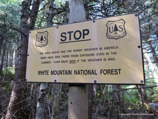
Flooding and high water crossings are also an area for concern after major rain events and in the spring, although there are very few water crossings on trails that are actually of much concern provided you have some water crossing experience. When planning hikes, it’s best to check the weather forecast and trail conditions continuously for a few days before your hike, and have a plan B in case it’s prudent to postpone your original hike.
When planning above-treeline hikes, it is good to plan out a few escape routes below treeline, depending on the weather and time of year you hike. Below treeline hikes are generally safe in most weather, except in certain avalanche zones, and from flying debris or widow-makers. Search and RescueThe State of New Hampshire has started charging people for rescues in some cases. You can buy a Hike Safe Card for $25 per person or $35 per family, which is a form of insurance covering rescue costs. People who obtain the cards are not liable to repay rescue costs if they need to be rescued due to negligence on their part, regardless of whether they are hiking, boating, cross-country skiing, hunting, or engaging in any other outdoor activity. An individual may still be liable for response expenses, however, if such person is deemed to have recklessly or to have intentionally created a situation requiring an emergency response. People who possess a current New Hampshire Fish and Game hunting or fishing license, or a current registration for an off-highway recreational vehicle, snowmobile or boat, are also exempt from repaying rescue costs due to negligence. If you require a rescue in the White Mountains and have a cell phone, dial *77. If you are physically in NH and on a land line, call 1-800-525-5555. They will answer 24 hours a day and will initiate the rescue. The NH Fish and Game dispatcher has very limited hours and isn’t a good number to call if you need to preserve your cell phone battery. They request that you call the State Police number instead. Note: Cell phone service can be very spotty in the White Mountains although it has improved in the past few years. Your best alternative is often self-reliance and proper preparation. 
BearsThere are black bears. Many of the AMC and some USFS managed campsites have bear boxes, but you should be prepared to hang your food with a bear bag or by using an Ursack when camping at less developed or backcountry sites. The USFS is quite vigilant about patrolling for bear bags at campsites, particularly in The Great Gulf below Mt Washington, and will cite people who don’t hang their food. The USFS also loans out bear canisters at the Lincoln Woods Trailhead, although they’re not mandatory yet in the National Forest. WaterWater is generally abundant in the White Mountains, although you may need to drop down side trails when hiking above-treeline to resupply. Carry a map, so you can locate natural water sources. Filtering or water purification of backpacking is highly recommended.
Additional ResourcesNew Hampshire’s White Mountain National Forest is a fantastic place to backpack. This quick and dirty guide provides all the information you need to get started in planning next adventure including camping, shelter, and trail system information, recommended maps, permits and regulations, travel, weather, and more. If you’re interested in backpacking in the area, be sure to check out my free guidebook, Backpacking the White Mountain 4000 Footers, which has a growing variety of backpacking trip plans to the high peaks and other scenic destinations. Written 2018. Disclosure: SectionHiker.com receives affiliate compensation from retailers that sell the products we recommend or link to if you make a purchase through them. When reviewing products, we test each thoroughly and give high marks to only the very best. Our reputation for honesty is important to us, which is why we only review products that we've tested hands-on. Our mission is to help people, which is why we encourage readers to comment, ask questions, and share their experiences on our posts. We are independently owned and the opinions expressed here are our own.The post Backpacking in the White Mountains: A Quick and Dirty Guide appeared first on Section Hikers Backpacking Blog. from https://sectionhiker.com/backpacking-in-the-white-mountains-a-quick-and-dirty-guide/
I’m headed down to the Pennsylvania Appalachian Trail this spring to finish section hiking the state. It’s tough living in Massachusetts or New Hampshire and getting down south to finish the trail on section hikes, but I am shooting to finish the AT by the end of 2020 so I can start hiking some other shorter, long distance trails. By March, I start to get cabin fever in New Hampshire, where I do most of my backpacking. The winter snow lasts well into May and it’s challenging to get out. But spring arrives earlier in the mid-Atlantic states, so I like to head down south each March or April and hike a portion of the Appalachian Trail. It’s still on the cold side in terms of temperature, but the snow is gone, and I prefer hiking the trail when it’s less crowded. The pace of my section hiking the AT has fallen off in recent years because I fell in love with backpacking in New Hampshire when I started section hiking the state in 2009. But I finished a major hiking/backpacking milestone last July when I finished hiking all 608 trails in The White Mountain Guide (becoming the 36th finisher) and feel the time is right to get back to hiking the Appalachian Trail. I hope to finish my loose ends in Pennsylvania (180 miles), New Jersey (10 miles) and Maine (50 miles) this year, so I can finish the rest of Virginia in 2019 and wrap up the trail in 2020. Some November section hikes are not out of the question, when backpacking in New Hampshire gets too dark and cold to be much fun. Part of my ritual preparation for long section hikes is figuring out what weather conditions I’m likely to encounter and modifying my gear list accordingly. I’ve been to this area before during the same time of year, so I know to expect:
Shelter/Sleep SystemI’m convinced that hammocks are the best shelter for hiking the Appalachian Trail because they give you maximum flexibility in terms of campsite location and the freedom to avoid noisy shelter mates. Hammocks are easy to pitch in the rain (tarp first) so your hammock and sleep insulation doesn’t get wet and there’s no shortage of trees to hang from. While it’s true that cold weather hammocking is a bit bulky since you need a warmer top quilt, bottom quilt, and an extra wind protector (called a hammock sock), I sleep much more deeply in a hammock than I do on the ground and have come to prefer it over a ground-based shelter. BackpackI carry a 55L Hyperlite Mountain Gear Southwest 3400 Backpack to accommodate my cold weather hammock insulation. In warmer weather, I switch to a lower volume (40L) version of the same pack. It’s not the lightest cuben fiber backpack you can buy, although it is one of the most durable. I also like the way it fits. Stove, Cooking, FoodThere’s nothing like a hot meal after a cold day of hiking and I have no issues with carrying a stove and pot to cook at night. I use Esbit fuel cubes to boil water, so my stove and cook pot weigh virtually nothing. Going stoveless in cold spring weather sounds utterly unappealing, to me at least. Most of my hot meals are GLOP based around wheat cereal, polenta, or pasta and quite easy to clean up. I prefer eating real food when I hike instead of “backpacking food”, which means I eat wheat bread, peanut butter, honey, cheese, and everyday foods on the trail. It’s also easy to resupply even in crappy gas station marts and convenience stores. ElectronicsThe biggest change in my hiking gear over the past few years has been in the area of electronics. I used to carry a big bag of extra batteries, all in different sizes, for different devices including my camera, headlamp, cell phone, and satellite communicator. They’ve all been replaced by a single battery recharger which I top off in town. That really simplifies things. ClothingAll my clothes are also tick-resistant and have been treated with Insect Shield or Permethrin. Lyme disease is no joke and is the most dangerous thing on the AT, as far as I’m concerned. I haven’t caught it yet and don’t plan to. The only other condition I pack for specifically is rain, which is impossible to avoid on the AT. You’re going get wet, either from rain or sweat, but the thing I dread most is being cold and wet. I’ve packed some rain mitts I picked up this year, in addition to my NON-breathable and inexpensive rain jacket (with pit zips) and my regular non-baggy rain pants. I thought about bringing some of the rain jackets I want to review this spring, but decided against it since this is supposed to be a vacation. Summing UpThe weight of my section hiking gear list comes out to be just under 15 pounds. It’s definitely not ultralight, but then again it’s hard to break the 10 pound limit in early spring when it’s so cold at night. The weight of my gear list really depends on the season more than anything. I’m a strong hiker and a couple of extra pounds aren’t going to slow me down. See Also:Written 2018. Disclosure: SectionHiker.com receives affiliate compensation from retailers that sell the products we recommend or link to if you make a purchase through them. When reviewing products, we test each thoroughly and give high marks to only the very best. Our reputation for honesty is important to us, which is why we only review products that we've tested hands-on. Our mission is to help people, which is why we encourage readers to comment, ask questions, and share their experiences on our posts. We are independently owned and the opinions expressed here are our own.The post Pennsylvania Appalachian Trail Section Hike Gear List – Spring 2018 appeared first on Section Hikers Backpacking Blog. from https://sectionhiker.com/pennsylvania-at-section-hike-gear-list-spring-2018/
The Osprey Exos 58 Backpack is one of the most popular backpacks used by thru-hikers and lightweight backpackers because it combines the organizational layout of a top-lid backpack, lightweight materials, and a rigid internal frame capable of hauling heavy loads. The most notable change in the 2018 Exos 58 preserves those characteristics but eliminates the hip belt pockets and shoulder strap storage which many backpackers count on to store snacks, insect repellent, and electronics. Time will tell how backpackers will respond to the lack of these accessory pockets, but the Exos remains one of the few mainstream “ultralight class” backpacks available with a true frame and back ventilation, which are must-have features for a large percentage of backpackers. Specs at a Glance
Organization and StorageThe Osprey Exos 58 is very different from most ultralight backpacks because it’s configured with a floating top lid instead of a dry-bag style roll top. With two zippered pockets (one pocket on top and one inside), the floating lid lets you sandwich extra gear between the lid and the top of the pack’s main compartment so you can carry extra technical equipment or supplies that won’t fit inside your pack. Top lids are a great feature, especially when you need to carry bulky gear like rope coils or tent bodies that won’t fit into the main compartment of your pack. The extra top pockets also provide handy access to hats, gloves, snacks, and navigation gear. If you don’t need the top lid on the Exos, you can remove it to save gear weight. This reduces the weight of a medium-sized Exos 58 by 5.4 ounces bringing it down to a very respectable 2 pounds 4.6 ounces. 
There’s a nylon flap under the top lid that is permanently attached to the pack, what Osprey calls a FlapJacket, that covers the drawstring opening of the main compartment. When you remove the top lid, the FlapJacket is used to protect the main compartment from rain in its stead. The rear of the FlapJacket also clips into the same rear straps and buckles used by the top lid so you’re not left with any extra straps or buckles to get in the way. While the Exos 58, also has good open storage in the form of side and front mesh pockets, the main compartment is where the bulk of this pack’s capacity is. With close to 3500 cubic inches of room, you can put a ton of gear and food inside. Being a mainstream manufacturer, Osprey computes the volume of their packs using industry norms and only counts covered and zippered storage when they calculate backpack volume. If you are comparing the volume of the Exos 58 with a pack from a cottage backpack maker, be aware that they often add in open and closed pocket volumes, so the Exos 58 may feel quite a bit larger. The main compartment curves sharply inward to accommodate the shape of the ventilated frame, but can make it difficult to locate gear because you need to reach around the curve to get to it. When packing the Exos 58, you also need to position that the heaviest items as close to your back as possible, otherwise the pack has a tendency to pull you backwards and off-balance. This is a common issue with ventilated backpacks, and while pulling the Exos’ load lifters forward can help reduce the back-tilt, the backward pull is quite noticeable when the pack is heavily loaded. 
With the exception of a hydration pocket, hang loop, and top compression strap, there’s nothing inside the Exos 58 main compartment like a sleeping bag compartment or interior pockets to break up the seemingly cavernous space. Still it’s easy to see inside the main compartment because lightly colored fabric panels help channel light to the pack’s interior. In addition to the main compartment, the Exos 58 has two stretch side mesh pockets which can be used to store water bottles.The mesh is not strong enough for off-trail travel and I would recommend you stay on trails with this pack in order to keep the pockets from tearing. Each pocket is reinforced with solid fabric on the bottom for better durability and has a holster-style opening cut in front, which lets you position bottles sideways so you can pull them out and replace them when on the move. I’d just caution against using tall bottles or packing small items in the side pockets because they fall out of the holster sized water bottle holes. There is also a front mesh shovel pocket on the back of the pack which is useful for carrying items that you want easy access to, without requiring that you stop and open your backpack. I can’t live without a mesh pocket like this and use it to stuff light layers and snacks that I want easily accessible during the day. External Attachment Points and Compression SystemThe Osprey Exos 58 has one Z-style side compression strap on each side of the pack. The strap can be threaded in front of or through the side water bottle pocket, which is handy because they won’t get in the way if you run them outside the pocket. Still, I’m not a huge fan of the Z-style threading pattern because I think it makes it difficult to strap bulky gear like snowshoes to the side of a pack. 
But don’t let the Z-style straps deter you from rigging up two horizontal compression straps instead. One of the great things about the Exos 58 is the distribution of gear loops around the perimeter pockets, the pack bag seams, and even the top lid, making it easy to rig up your own custom compression system with an extra cord lock and some guyline or a piece of webbing. The other key attachment point on the Exos 58 is the sleeping pad strap on the bottom of the pack, a feature which has largely disappeared from the lightweight backpacking market. While the strap is optional and can be removed, it’s super handy to have if you’re a thru hiker, hammock camper or winter camper and carry a bulky foam pad to sleep on at night. Backpack Frame and SuspensionThe Osprey Exos 58 is a ventilated “trampoline-style” backpack. Breathable mesh is suspended in front of the back panel creating a ventilated space behind your back that’s designed to evaporate sweat before it can soak your shirt. The mesh is tightly stretched across the aluminum frame, hence the name trampoline, which also serves to anchor the hip belt and load lifters. 
The aluminum frame on the Exos 58 is the secret sauce that “makes” this pack. It’s super lightweight and stiff, providing great load transfer to the hips, so you can really load up this pack and still get a very comfortable carry. The nice thing about an aluminum frame is that the torso won’t collapse, causing the torso length to shorten when you load the pack to capacity, which can be an issue with other lightweight packs. The shoulder straps and hip belt are both covered with a stretchy mesh fabric that is soft and helps wick moisture to prevent rubbing and chafing. While they’re both well padded so they conform to the shape of your collarbone, shoulders, and hips and don’t slip. 
But there’s one thing about the Exos 58 that I don’t particularly like and that’s the length of the hip belt, which I think is too short. There is simply no way that the size medium Exos 58 fits someone with a 27-48″ waist. I think a maximum of 38″ is a more realistic upper limit. If you buy an Exos 58 and the hip belt padding only wraps around the back of your hips, which happens when the hip belt is too short, you won’t be as comfortable or get the load transfer you should expect. This isn’t just a sizing issue with the Exos 58, but a sizing issue that I repeatedly encounter with Osprey Packs that don’t have adjustable hip belts. If the front padded portion of the Exos hip belt doesn’t wrap around the front of your hip bones (see How should a Hip Belt Fit?), get a larger size. If that still doesn’t fit, buy a different backpack. Likes
Dislikes
RecommendationThe Osprey Packs Exos 58 Backpack is a top-loading backpack that’s easy to configure for many different kinds of hiking and backpacking trips. Weighing just 2 pounds 11 ounces, it boasts a stiff aluminum frame and ventilated suspension that provides excellent comfort and control for loads up to 30-35 pounds. If you want a large but lightweight (58L) backpack with a real frame and a top lid, the Exos 58 is a great choice. Sizing can be a little tricky however, since the hip belt lengths available are tied to the torso length of the pack. If the Exos 58 fits you, great. It’s an excellent backpack. If it doesn’t fit, give it a pass. For complete specs, I suggest you visit the Exos 58 product page at REI since the Osprey Packs Sizing Guide at OspreyPacks.com can be difficult to understand. Disclosure: The author owns this product and purchased it using their own funds. Written 2/2018. Disclosure: SectionHiker.com receives affiliate compensation from retailers that sell the products we recommend or link to if you make a purchase through them. When reviewing products, we test each thoroughly and give high marks to only the very best. Our reputation for honesty is important to us, which is why we only review products that we've tested hands-on. Our mission is to help people, which is why we encourage readers to comment, ask questions, and share their experiences on our posts. We are independently owned and the opinions expressed here are our own.The post Osprey Exos 58 Backpack Review (2018 Model) appeared first on Section Hikers Backpacking Blog. from https://sectionhiker.com/osprey-exos-58-backpack-review-2018/ |

ABOUT MEHello my pleaseure to introduce myself, I am Jose Johnson. I am 26 years old from Monroe, LA. I love to got for hikings with my friends on holidays. Archives
April 2019
Categories |


 RSS Feed
